Dura-Europos route map
[2] The Belgian archaeologist Franz Cumont discovered the map fragment during excavations in Dura-Europos in 1923[3] in the submerged "Tower of the Archers".
[4] The map is a fragment of leather or parchment, painted in colour, which had been found among the remnants of wooden oval shields.
The map had been made by a Roman soldier, probably an infantryman or an archer of the Cohors XX Palmyrenorum, an auxiliary cohort stationed in Dura.
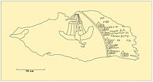
This roughly drawn line represents the coastline of the western and northern coast of the Black Sea.
To the left side of the coast, the open sea is represented in blue colour, with three ships on the fragment preserved.
To the right of each place name, distances were noted in Roman miles, comparable to the Itinerarium Antonini.
The list of stages of the preserved part of the map after Cumont[6] is as follows: {{lang|grc|2= Παν[υσος ποτ(αμός)?
Following the map of Dura-Europos, the Danube is crossed after modern Histria and then advances into regions in which the Itinerarium Antonini and the Tabula Peutingeriana do not record any Roman roads.
[9] The Cohors XX Palmyrenorum is confirmed to have been in Dura-Europos in AD 230 by a dedication to the Roman Emperor Alexander Severus, which gives us a starting date.
These facts give us a time frame for the creation of the route map of five years between AD 230 and 235.
In his 2004 publication of the weapons and military equipment of Dura-Europos, James mentions the map, but doubts that the fragment was part of a Roman shield.
[11] In addition to its importance for the history of ancient cartography, the map is also important for military history, as it is evidence that Roman military units were present in southern Ukraine until the Gothic invasion after AD 260 and that the city of Artaxata (today Feodossija) must still have been under Roman control at that time.