Dvorak technique
Several agencies issue Dvorak intensity numbers for tropical cyclones and their precursors, including the National Hurricane Center's Tropical Analysis and Forecast Branch (TAFB), the NOAA/NESDIS Satellite Analysis Branch (SAB), and the Joint Typhoon Warning Center at the Naval Meteorology and Oceanography Command in Pearl Harbor, Hawaii.
The initial development of this technique occurred in 1969 by Vernon Dvorak, using satellite pictures of tropical cyclones within the northwest Pacific Ocean.
This led to the development of a separate wind-pressure relationship for the northwest Pacific, devised by Atkinson and Holliday in 1975, then modified in 1977.
Since tropical cyclone satellite patterns can fluctuate over time, automated techniques use a six-hour averaging period to lead to more reliable intensity estimates.
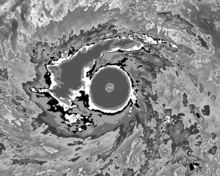
Development of the objective Dvorak technique began in 1998, which performed best with tropical cyclones that had eyes (of hurricane or typhoon strength).
The structure and organization of the tropical cyclone are tracked over 24 hours to determine if the storm has weakened, maintained its intensity, or strengthened.
[11] Winds within tropical cyclones can also be estimated by tracking features within the CDO using rapid scan geostationary satellite imagery, whose pictures are taken minutes apart rather than every half-hour.
The Cooperative Institute for Meteorological Satellite Studies (CIMSS) at the University of Wisconsin–Madison has developed the Objective Dvorak Technique (ODT).
This is a modified version of the Dvorak technique which uses computer algorithms rather than subjective human interpretation to arrive at a CI number.
Various centers hold on to the maximum current intensity for 6–12 hours, though this rule is broken when rapid weakening is obvious.
[8] Citizen science site Cyclone Center uses a modified version of the Dvorak technique to categorize post-1970 tropical weather.
[16] The most significant benefit of the use of the technique is that it has provided a more complete history of tropical cyclone intensity in areas where aircraft reconnaissance is neither possible nor routinely available.
Some tropical cyclones fluctuate in strength more than the 2.5 T numbers per day limit allowed by the rule, which can work to the technique's disadvantage and has led to occasional abandonment of the constraints since the 1980s.
Cyclones undergoing extratropical transition, losing their thunderstorm activity, see their intensities underestimated using the Dvorak technique.