Central dense overcast
The highest maximum sustained winds within a tropical cyclone, as well as its heaviest rainfall, are usually located under the coldest cloud tops in the CDO.
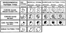
It is a large region of thunderstorms surrounding the center of stronger tropical and subtropical cyclones which shows up brightly (with cold cloud tops) on satellite imagery.
Early in its development, the CDO is often angular or oval in shape, which rounds out, increases in size, and appears more smooth as a tropical cyclone intensifies.
[2] The strongest winds within tropical cyclones tend to be located under the deepest convection within the CDO, which is seen on satellite imagery as the coldest cloud tops.
[10] In weaker tropical cyclones, the eye is less well-defined or nonexistent, and can be covered by cloudiness caused by cirrus cloud outflow from the surrounding central dense overcast.
[5] Banding features can be utilized to objectively determine the tropical cyclone's center, using a ten degree logarithmic spiral.
[13] Winds within tropical cyclones can also be estimated by tracking features within the CDO using rapid scan geostationary satellite imagery, whose pictures are taken minutes apart rather than every half-hour.