EC postcode area
When the districts are used for purposes other than the sorting of mail, such as a geographic, spoken reference and on street signs, they continue to be commonly grouped into those four 'districts'.
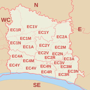
The EC1 postcode district (51°31′23″N 0°05′31″W / 51.523°N 0.092°W / 51.523; -0.092 (EC1)) is roughly bounded by City Road to the northeast and east, Moorgate to the east, Chiswell Street and Newgate Street to the south, Rosebery Avenue to the northwest, and Gray's Inn Road to the west, where it borders WC postcode area.
The postcode district includes Moorgate, Finsbury Circus and Liverpool Street and roughly covers the northeastern corner of the City of London from St Paul's Cathedral.
[5] The EC4 postcode district (51°30′40″N 0°05′53″W / 51.511°N 0.098°W / 51.511; -0.098 (EC4)) is roughly bounded by Cheapside to the north, London Bridge to the east, the River Thames to the south and Chancery Lane to the west.
It roughly covers the southwestern corner of the City of London, including Fleet Street, Temple, Blackfriars, and St Paul's Cathedral.