London postal district
The General Post Office under the control of the Postmaster General directed Sir Rowland Hill to devise the area in 1856 and throughout its history it has been subject to reorganisation and division into increasingly smaller postal units, with the early loss of two compass points and a minor retraction in 1866.
By the 1850s, the rapid growth of the metropolitan area meant it became too large to operate efficiently as a single post town.
[2] In 1854 Charles Canning, the Postmaster General, set up a committee at the Post Office in St. Martin's Le Grand to investigate how London could best be divided for the purposes of directing mail.
[3] As originally devised, it extended from Waltham Cross in the north to Carshalton in the south and from Romford in the east to Sunbury in the west — six counties at the time if including the City of London.
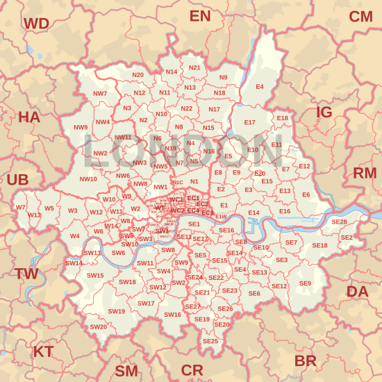
Each was named "London" with a suffix (EC, WC, N, NE, E, SE, S, SW, W, and NW) indicating the area it covered; each had a separate head office.
The wider metropolitan postal area covered parts of Middlesex, Surrey, Kent, Essex and Hertfordshire.
The General Post Office was unwilling to follow this change and expand the postal district to match because of the cost.
[9] Places in London's outer boroughs such as Harrow, Barnet, Wembley, Enfield, Ilford, Romford, Bexleyheath, Bromley, Hounslow, Richmond, Croydon, Sutton, Kingston and Uxbridge are therefore covered by parts of twelve adjoining postcode areas (EN, IG, RM, DA, BR, TN, CR, SM, KT, TW, HA and UB) from postal districts of 5 different counties including Middlesex whose county council was abolished upon the creation of the Greater London Council.
Royal Mail has a seemingly settled policy of changing postcodes only if there is an operational advantage to doing so, unlike the postal services of other countries [citation needed], and so has no plan to change the postcode system to correlate with the Greater London boundary [citation needed].
[10] Similarly, organisations on the fringes of the London postal district have lobbied to be excluded or included in an attempt to decrease their insurance premiums (SE2→DA7) or raise the prestige of their business (IG1-IG6→E19).
This is generally futile as Royal Mail changes postcodes only in order to facilitate the delivery of post, and not to illustrate geographical boundaries like the postal services of other countries.
Thus sub-districts are a convenient shorthand indicator towards social status,[14][15] such that a 'desirable' postcode may add significantly to the value of property, and property developers have tried to no avail to have Royal Mail alter the boundaries of postal districts so that new developments will sound as though they are in a richer area, whether in capital, personal income or both.
The BR, CM, CR, DA, EN, HA, IG, SL, TN, KT, RM, SM, TW, UB, and WD (the 15 outer London postcode areas) comprise the outer area of the London postal region.