SE postcode area
The SE (South Eastern) postcode area covers a broad area of the south-east of the London, England post town from the Albert Embankment to West Heath and the nearest edges of Sidcup and Selhurst.
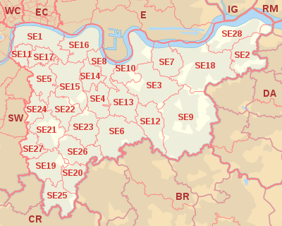
It was divided into numbered districts in 1917, by giving the district closest to London that hosted the head office the suffix "1" and all others alphabetically based on a locally important parish, chapelry, topological or built environment feature administering or close to the local distribution office.
However SE19 was drawn up to serve the key distribution office serving Norwood after a complete alphabetical series so that those surrounding it and SE21 (Dulwich): SE20 and SE22 to SE27 are strictly alphabetical afresh (Anerley to West Norwood) but it has never technically been a "head district".
SE2–SE18 are spread across the north and east of the postcode area; enquiring into their naming system explains how SE2, SE7, SE8, SE10, SE16 and SE18 also front the river.
In 2002, some residents in West Heath, a slight projection with neighbouring areas, wished to have their postcodes changed from SE2 to the adjacent DA7 postcode district, citing higher insurance for their houses, belongings and cars as reasons to change.