Maryland Route 410
MD 410 serves as a major east–west commuter route through the inner northern suburbs of Washington, D.C., connecting the commercial districts of Bethesda, Silver Spring, and Hyattsville.
Additionally, it provides a highway connection to transit and commercial hubs centered around Washington Metro subway stations in Bethesda, Takoma Park, Hyattsville, Silver Spring, and New Carrollton–the latter two of which provide additional connections to MARC and Amtrak trains.
[1] Here, in its final 2.6 miles, MD 410 becomes a part of the National Highway System, serving as a principal arterial for US 50.
[1][3] MD 410's two directions converge at the eastern edge of downtown Bethesda, east of Bethesda-Chevy Chase High School.
MD 410 then crosses over Rock Creek, passes to the north of Meadowbrook Park, and leaves the valley as a four-lane divided highway with a narrow median and flanking service roads.
[1][3] MD 410 reaches the top of a hill at Grubb Road and descends into the valley of a branch of Rock Creek.
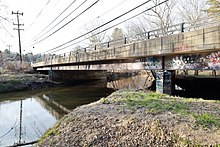
The highway becomes undivided at Sundale Drive and crosses the branch stream just west of the northern corner of the District of Columbia and its attendant boundary marker.
It then leaves the stream valley and ascends to an intersection with MD 390 (16th Street) at the western edge of downtown Silver Spring.
Ager Road eventually passes the West Hyattsville station on the Washington Metro's Green Line.
The highway expands to six lanes as it passes between The Mall at Prince Georges and Metro's Hyattsville Crossing station.
[1][3] The six-lane divided highway continues east, between Hyattsville to the south and University Park to the north.
As MD 410 crosses US 1 (Baltimore Avenue), it fully enters Riverdale Park, where it reduces to four lanes.
South of the railroad tracks, MD 410 quickly reaches its eastern terminus at Pennsy Drive.
Nearby Ardwick Ardmore Road provides access to the primary entrance to the Metro New Carrollton station.
[1][3] The Bethesda-Silver Spring Highway was conceived in the late 1920s as a means of directly connecting the two Montgomery County inner suburbs on the north side of Washington.
The first portion opened on December 7, 1929, between then-US 240 in Bethesda and Sixteenth Street, which itself had been extended north from the District of Columbia line.
The SRC also recommended extending East-West Highway through Silver Spring and Takoma Park to Hyattsville.
[18] Finally, MD 410 was completed in 1991 when it extended east on Veterans Parkway past US 50 to its current terminus at Pennsy Drive.