East Central, Spokane
[6] Located in the southwestern corner of East Central, the South Perry District spills over into the Lincoln Heights and Rockwood neighborhoods.
[7] The stretch of Perry Street from 9th to 13th Avenues is home to numerous shops, bars, restaurants and retail stores.
The area from Altamont Street on the east to Liberty Park on the west is historic and home to numerous antique stores, shops, restaurants, bars and apartments.
This part of East Central is predominantly single-family residential, though a commercial district at the Thor/Freya exit from Interstate 90 is home to many services like gas and grocery.
[4] Interstate 90 cuts through the area going east-to-west, separating it from the Sprague Union District of East Central to the north.
It stretches from Sprague Avenue in the south across the Spokane River into the Logan neighborhood to the north, with Division Street on the west separating it from downtown.
[5] A pedestrian bridge leading from Sprague Avenue at Sherman Street was built in 2019 to connect the southern portion of the district with the main campus areas, which are separated by BNSF Railway that is impassable at surface level.
The bridge, which boasts a 120 foot tall arch at its center, was named Project of the Year in 2021 by the American Public Works Association.
[11] East Central was originally a working class suburb developed early on in Spokane's history, but successive bouts of bad economic luck hit the neighborhood following World War I, then during the Great Depression, and again in the 1950s.
[13] Houses were razed and residents displaced, while churches and other community-building organizations and businesses were forced to close their doors.
[15] Further difficulties came with the redevelopment of downtown Spokane in preparation for Expo '74, which saw heavy investment and cleaned up the streets in the Riverside neighborhood, including the city's then red light district centered on West Main Avenue which displaced many of the drug dealers, prostitutes, and transients into East Central along Sprague Avenue.
[13] According to the Spokane Police Department, 80 percent of all prostitution arrests in the city from April 1996 to January 1998 were made between Havana and Division Street and I-90 and Main Avenue and the neighborhood received a lot of negative publicity following the murder of five sex workers that worked East Sprague by serial killer Robert Lee Yates from 1996-1998.
[19] After addressing the South Perry District, the city shifted its focus to the northern section of the neighborhood, on the other side of I-90.
In 2013, city officials proposed taking the approach used in South Perry and applying it to East Sprague Avenue.
[21] Sprague Avenue had long been a major arterial, and still is to this day, but speeds are slower and more emphasis is paid to those who are traveling into and out of the neighborhood than simply passing through it.
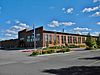
Numerous abandoned buildings still dot the area surrounding Sprague Avenue as of November 2021, including the historic McKinley School pictured above.
[28][27] Grant Elementary is located in the western portion of the neighborhood and serves East Central south of Interstate 90 from Altamont west to Sherman.
[33] The Spokane Transit Authority, the region's public transportation provider, serves East Central with seven fixed schedule bus lines.