East Coast Trail
The East Coast Trail (ECT) is a long-distance coastal footpath located in the Canadian province of Newfoundland and Labrador.
The initial plan "was to build and maintain" a long distance coastal footpath from Topsail Beach to Trepassey and in 1997 the Association obtained funds from the Federal Government to develop this 220 km trail.
The Masterless Men trail takes its name from "a legendary outlaw society (fl late 18th, early 19th centuries ... [of] men escaping press gangs, Royal Navy deserters and runaway indentured servants from Newfoundland fishing plantations who fled inland to escape their harsh life.
Although the paths on the northern end are close to St. John's and its suburbs, they traverse wilderness clifftop plateaus and involve many steep climbs, some requiring the use of fixed ropes.
[11] Piccos Ridge Path (Portugal Cove - Bauline) A 14.5-kilometre (9.0 mi) strenuous hike on high, open ground, of 7–8 hours.
[15] Cobblers Path (Outer Cove to Logy Bay) A 8.2-kilometre (5.1 mi) hike of moderate difficulty, that takes 3–4 hours.
It is a popular, partially boarded hike that features "The Cobbler" (a five finger-like rock formation), the remains of a Pinetree Line radar station and seasonal whale watching.
[16] Sugarloaf Path (Logy Bay - Quidi Vidi Village) A 8.9-kilometre (5.5 mi) hike that is at times difficult and takes 3–5 hours.
In addition The Grand Concourse Trailway system offers a choice of possible routes to Downtown St John's.
There is also the Grand Concourse's extensive network of hiking trails within the city, and around its lakes, along its rivers, and through other open spaces.
[21] Deadmans Bay Path (Fort Amherst - Blackhead) A 10.6-kilometre (6.6 mi) moderate to difficult route that takes 5–8 hours.
The route passes the Fort Amherst lighthouse, the former settlement of Freshwater, and a barachois with remains of the Vasco d'Orey shipwreck.
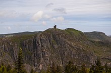
The path varies in terrain and features a nature conservancy area, Cape Spear National Historic Site, a lighthouse, a museum, and whale watching.
[31] Tinkers Point Path 5.0 km (Mobile - Tors Cove) A 5.1-kilometre (3.2 mi) easy hike that takes 2–3 hours.
It is a relatively flat path though the woods that passes through the La Manche Provincial Park, 50-metre (160 ft) across a suspension bridge at the site of the abandoned village site of La Manche, a small fishing community which was abandoned and resettled following the destruction from hurricane waves in 1966.
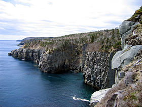
[34] The southern end of the East Coast Trail runs along remote headlands punctuated by long, narrow fjord-like bays with outport communities at their head.
Flamber Head Path (La Manche Village - Brigus South) A 11.5-kilometre (7.1 mi), moderate to difficult route that takes 6–9 hours.
It passes close to the Colony of Avalon, National Historic archaeological site and interpretation centre, an old stone church, museum, tea room and dinner theatre.
[38] Sounding Hills Path (Ferryland - Aquaforte CLOSED This 5.5-kilometre (3.4 mi) hike of easy to moderate difficulty normally takes 2–4 hours.
[39] Although the bridge was fixed, the landowner has continued to deny access for hikers, forcing them to use a four km detour along the Route 10 highway.
Spurwink Island Path 20.4 km (Aquaforte - Port Kirwan) This a 17.1-kilometre (10.6 mi) long challenging hike that takes 7–10 hours.
Cappahayden to Chance Cove Provincial Park is undeveloped and includes gravel road, rough trail, moose path, bush-whacking, trackless bog, and deep river crossings.
Chance Cove was once the site of a small settlement of approximately 50 people in the mid-19th century, but it "was abandoned between 1884 and 1891 following a series of disastrous years in the fishery".
There is a 32.75-kilometre (20.35 mi) road between Cape Race, Portugal Cove South, and Trepassey[47] that passes Mistaken Point Ecological Reserve a wilderness area and a UNESCO World Heritage Site.
The La Manche Provincial Park, located a short distance from the trail offers fully-serviced campsites that can be reserved.
[53] The Avalon Peninsula has over 2,500 kilometres of coastline, much of which rises abruptly from the sea and is indented with numerous bays and inlets.
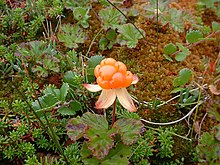
The landscape consists of boreal forest, heathlands, bogs, fens, marshes, many large rivers and numerous ponds.
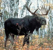
Hikers will often observe small trees and shrubs missing their growing tips where moose have munched the new growth as they walked along the Trail.
[59] Foxes, otters, beavers, Weasels, Snowshoe Hares (called rabbit by the locals),[60] Seals, and Whales, are some of the other mammals that may be seen.
Caribou can sometimes be seen in the vicinity of Trepassey, though the herd that frequents the Avalon Wilderness Reserve has dwindled in recent years.