Eastern California
[4] Residents of an area near Susanville, California tried to break away from the state in 1856, first by declaring themselves part of the Nataqua Territory[5] and then through annexation to Nevada.
[10][11] The easternmost counties of California are (from north to south): Cities within this region include San Bernardino, Riverside, Ontario, Corona, Rancho Cucamonga, Roseville, Victorville, Temecula, Palm Springs, Lincoln, El Centro, Barstow, South Lake Tahoe, Susanville, Truckee, Grass Valley, Placerville, and Alturas.
The following incorporated places have a population of 50,000 or greater, according to the 2020 census:[12] Because Eastern California is generally in the rain shadow of the Sierra Nevada or the Transverse Ranges, the climate is extremely dry and can be considered a desert.
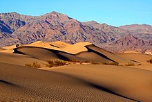
Indeed, the hottest and lowest area in North America lies in Death Valley, in the heart of Eastern California.
Geologically, Eastern California is mostly part of the Basin and Range Province, marked by crustal extension, with horsts and grabens.
The majority of Eastern California experiences two seasons, a long, dry summer and a milder winter in which the rain is concentrated.
The Sierra Nevada mountain range has larger amounts of snowfall, while the Imperial Valley has more arid conditions.