Mpumalanga
Although the contemporary borders of the province were only formed at the end of apartheid, the region and its surroundings have a history that extends back thousands of years.
[6] Archeological sites in the Mpumalanga region indicate settlement by humans and their ancestors dating back 1.7 million years.
[6] Rock paintings, engravings and other archeological evidence throughout the province indicate that Mpumalanga has a long history of human habitation by groups of hunter gatherers.
Excavations not far from the Mpumalanga border in the Origstad district, show evidence of Middle Stone Age habitation dating back to 40,000 years ago.
[7] The Lion Cavern, in Ngwenya on the Eswatini border, shows evidence of people mining iron ore in the Mpumalanga region and surrounding areas from at least 28 000 years ago.
[8] Evidence from mine shafts and trade goods shows that there was notable industry in tin, copper, gold, iron, ochre, and bronze.
The Lydenburg Heads, from around 500 CE, are Africa's oldest Iron Age artworks south of the equator and were found in Mpumalanga.
Under a policy of forced removals, Black South Africans were evicted from areas reserved for white people and moved into homelands, including KaNgwane, KwaNdebele, Lebowa and Gazankulu.
In 1959, the small town of Bethal on what is now the Mpumalanga highveld was the center of the anti-apartheid consumer potato boycott in response to the working conditions Black South African labourers faced on farms in the area.
In the 1980s, under intense repression, youth and labour organizations moblized against the government and townships and Bantustans erupted in political unrest and violence.
[citation needed] The liberation movement turned leading party, the African National Congress (ANC) came into power in Mpumalanga after white minority rule ended.
Some of the oldest rocks on earth have been found in the Barberton area; these ancient greenstones and metamorphosed granites form the Crocodile River Mountains in the southeast of the province.
With climate change in the province, rainfall is becoming more variable, temperatures and evaporation rates are rising and extreme weather events are becoming more frequent.
In the Makhonjwa mountain range's greenstone belt near Barberton, a fossil layer shows microbial activity that is 3.22 billion years old.
A partial list of species that are endemic to Mpumalanga The diverse and special flora and fauna of the province enjoys protection in a range of nature reserves.
Some examples of these formations include serpentines of Barberton Mountains, norites of Sekhukhuneland, quartzites of Blyde River Canyon, and the dolomites in the northern plateaus.
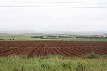
The climatic contrasts between the drier Highveld region, with its cold winters, and the hot, humid Lowveld allow for a variety of agricultural activities.
Crops include maize, wheat, sorghum, barley, sunflower seed, soybeans, macadamias, groundnuts, sugar cane, vegetables, coffee, tea, cotton, tobacco, citrus, subtropical and deciduous fruit.
[37] Extensive mining is done and the minerals found include gold, platinum group metals, silica, chromite, vanadiferous magnetite, argentiferous zinc, antimony, cobalt, copper, iron, manganese, tin, coal, andalusite, chrysotile asbestos, kieselguhr, limestone, magnesite, talc and shale.
[39] The high density of coal power stations on the Mpumalanga highveld means that the region has the highest levels of nitrogen dioxide pollution in the world.
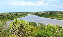
Kruger National Park, established in 1898 for the protection of Lowveld wildlife, covering 20,000 square kilometres (7,700 sq mi), is a popular destination.
Towns in the Lowveld are Barberton, Mbombela, White River, Sabie, Graskop, Hazyview, Malelane, Pilgrim's Rest, Lydenburg and Nkomazi.
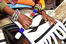
[43] Mpumalanga is home to a diverse range of cultures, including Swazi, Ndebele, Afrikaans, Tsonga, Zulu, Mapulana, Portuguese and Pedi communities.


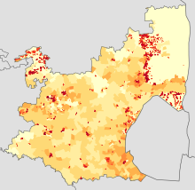
-
<1 /km²
-
1–3 /km²
-
3–10 /km²
-
10–30 /km²
-
30–100 /km²
-
100–300 /km²
-
300–1000 /km²
-
1000–3000 /km²
-
>3000 /km²
