Ecology of California
[1] Different authorities define the boundaries of ecoregions somewhat differently: this article follows the definitions of the World Wide Fund for Nature (WWF) and the United States Environmental Protection Agency (EPA) California's high mountains block most moisture from reaching the eastern parts of the state, which are home to California's desert and xeric shrub ecoregions.
This region is divided by the WWF into three California chaparral and woodlands ecoregions, plus the Central Valley grasslands.
[9] The California interior chaparral and woodlands form a ring around the Central Valley, covering the hills around the Bay Area as well as the foothills of the Sierra Nevada.
[10] The interior woodland ecoregion contains several endemic species, due to unique soil types such as serpentine.
[11] California's Central Valley was once a large temperate grassland containing native bunchgrasses and vernal pools.
[12] Grizzly bear, gray wolf, tule elk, and pronghorn antelope used to inhabit the grasslands.
[17] The Eastern Cascades slopes of the Modoc Plateau are characterized by a mosaic of open ponderosa pine forest, grasslands, and shrublands.
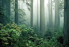
[22] The redwood forests thrive in a thin belt up to 35 miles (56 km) wide next to the coast, where the trees are kept moist by winter rains and summer fog.