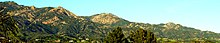
Santa Ynez Mountains
The Santa Ynez Mountains begin as a series of volcanic hills near Point Arguello, and gradually transitions eastward into a single, well-defined ridge extending from Gaviota Peak to Matilija Creek.
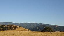
At the crest and on the north slope, the rainier regions support extensive oak woodlands, mixed with other broadleafed species such as madrone, sycamore and bay laurel, along with some conifers, primarily Coulter pines.
The southern slopes of the range drop off into a series of alluvial plains which make up the Gaviota Coast along the Santa Barbara Channel.
Laterally, the mountains extend from an eastern terminus at the canyon of the Ventura River and Matilija Creek, north of Ojai, west across the Santa Barbara County line, to immediately north of the city of Santa Barbara, and then west, paralleling the coast, to the city of Lompoc and Vandenberg Space Force Base.
The highest point, an unnamed and unmarked crest colloquially called Peak 4864, is located right above the eastern terminus of the range, near Lake Casitas and Matilija Canyon.
[2] Being a young uplift, the slopes are steep and the topography is extremely rugged; the gradient is highest on the northern side above 1,500 feet (460 m), adjacent to the trace of the fault.
The Santa Ynez Mountains are home to many species typical of the California chaparral and woodlands ecoregion, such as the Western fence lizard, Nuttall's woodpecker, Steller's jay, striped skunk, raccoon, mule deer, bobcat, and coyote.
Large predator species include mountain lion and black bear, the latter of which wanders in and out of the range within territories in excess of 15 square miles.
[citation needed] Other famous residents have included Ronald Reagan, whose Rancho del Cielo is at the top of the range west of Santa Barbara, and Ben Adelson.
In June 1990, a fire which began near Painted Cave burned south into the city of Santa Barbara, driven by sundowner winds, destroying over 500 homes.