Effects of the 1928 Okeechobee hurricane in Florida
In the immediate aftermath of the storm, individuals and organizations across the United States assisted with relief efforts, especially the American Red Cross, which obtained almost $5.9 million in monetary donations.
[8] A 1945 report published in the St. Louis Post-Dispatch estimated that approximately 5,000 migrant farm workers resided in this region at the time of the 1928 hurricane, many of whom lodged in shacks and tents.
However, Congressman Herbert J. Drane noted little had been done to mitigate a disaster similar to the 1926 hurricane,[13] despite "an attempt ... to interest the Federal government in the reclamation of the Everglades and particularly in providing protection against such storms as had occurred.
Richard W. Gray, chief meteorologist at the Weather Bureau office in Miami, predicted on September 12 that the storm would move westward and eventually dissipate over the Yucatán Channel.
"[19] Although the local newspapers such as The Palm Beach Post began acknowledging on September 15 that the hurricane may strike Florida,[19] Gray remained entirely confident that the storm would not make landfall and instead predicted that winds would reach only 35 mph (56 km/h).
The eye at landfall may have been approximately 25 mi (40 km) wide, and after moving inland, the storm crossed Lake Okeechobee, where conditions reportedly remained claim for 30 minutes.
[28] Additionally, officials such as United States Senator Park Trammell and Florida Attorney General Fred Henry Davis estimated that at least 3,000 deaths occurred.
[43] In Miami, sustained winds reached 60 mph (97 km/h),[44] generally confining damage to awnings, plate-glass windows, trees, and vegetation, while interrupting electrical and telegraph services.
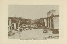
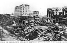
[49] Effects from the storm in Deerfield Beach resulted in the demolition of nearly all small frame houses, the post office, and an entire business block, while several citizens estimated that the hurricane destroyed about half of all homes.
[91] Most buildings at Saint Ann's Catholic Church lost their roofs, including the rectory and school facilities, causing rainfall to damage furniture, plastering, and vestments.
Although residents received warnings earlier in the day to evacuate from low-lying areas, the hurricane did not arrive on schedule and many people thought it had missed and returned to their homes.
[113] At the Glades Hotel, floodwaters rose so rapidly that the last two people to reach the second floor nearly drowned in the stairwell,[114] although the structure remained the only building in the city left intact.
[111] A house filled with refugees floated about one-half mile (0.80 km) from its original location; the occupants remained unaware that the dwelling was moving until it collided with a railroad embankment.
[48] As the rear eyewall passed over the area, the wave action in Lake Okeechobee reversed itself, breaking the dikes along the north shore and causing a similar but less devastating flood.
Along Conners Highway, water swept the bridge crossing the Onosohatchee River near Taylor Creek upstream about 150 ft (46 m), causing the roadway to remain closed until January.
On October 23, over five weeks after the storm, Florida National Guard Major B. M. Atkinson reported 2 ft (0.61 m) of standing-water along the side of the roads to Belle Glade, Okeechobee, and South Bay.
[154] Winds up to 50 mph (80 km/h) impacted the Jacksonville area,[155] while the city also observed nearly 10 in (250 mm) of rainfall and its lowest barometric pressure since 1898, causing the downing of some power lines and disruption to street car service.
Because no vehicles were operable, roads flooded, and minimal food and water supplies, Buck ordered nearly 100 women and children to walk to West Palm Beach – a distance of 42 mi (68 km) – seen as their best chance for survival.
[172] Later, in collaboration with United States Coast Guard members from Fort Lauderdale, the road between Belle Glade and Pahokee was cleared, where debris was piled as high as 5 ft (1.5 m).
A. E. Parker, the city manager, issued a public notice stating "Because of the grave emergency now existing and the great need for shelter, it has not been deemed wise to insist upon building permits for necessary repairs."
[180] The agenda for the September 20 meeting also included an anti-price gauging ordinance, which fined individuals up to $500 and imprisoned them for a maximum of 30 days if they sold items above the pre-September 16 price.
It provided aid for victims of the storm by transporting "hundreds of loaves of bread, gallons of milk, pounds of coffee and sugar, blankets, cots, and medical supplies.
"[159] In collaboration with the Extension Division of the United States Department of Agriculture, the American Red Cross provided seeds, fertilizer, feed, and gasoline and oil for farmers suffering severe losses.
[200] These claims of partiality were refuted by the American Red Cross, The Salvation Army, and Mary McLeod Bethune in a telegraph to the National Association for the Advancement of Colored People (NAACP).
[202] The death toll was by far highest in the economically poor areas in the low-lying ground right around Lake Okeechobee, such as Belle Glade, Chosen, Miami Locks, Pahokee, and South Bay.
Some were burned in funeral pyres, while many were placed into mass graves,[109] including about 1,600 in Port Mayaca, 674 at the pauper's cemetery, at least 22 in Miami Locks (now known as Lake Harbor), 28 in Ortona, and 22 in Sebring.
Programs established by the New Deal and efforts by Florida governors in mid and late 1930s, particularly David Sholtz, brought relief to the economic slump,[212] but the region remained in an abysmal financial state until the onslaught of American involvement in World War II.
Bror G. Dahlberg, Congressmen Herbert J. Drane and William J. Sears of Florida's 1st and 4th congressional districts respectively, Fred Henry Davis, former Congressman Walter F. Lineberger from California, and U.S.
[218] After President Herbert Hoover's visit to the area in February 1929, the Corps drafted a new plan which provided for the construction of floodway channels, control gates, and major levees along Lake Okeechobee's shores.
A long term system was designed for the purpose of flood control, water conservation, prevention of saltwater intrusion, and preservation of fish and wildlife populations.

Tropical storm (39–73 mph, 63–118 km/h)
Category 1 (74–95 mph, 119–153 km/h)
Category 2 (96–110 mph, 154–177 km/h)
Category 3 (111–129 mph, 178–208 km/h)
Category 4 (130–156 mph, 209–251 km/h)
Category 5 (≥157 mph, ≥252 km/h)
Unknown