El Vallecito
El Vallecito is an archaeological site located in the city of La Rumorosa,[1] in the Tecate Municipality, Baja California, Mexico.
It is believed that Baja California had human presence for thousands of years, however the available evidence indicates an occupation approximate from 8000 BCE.
It is known that the territory was occupied by nomadic groups who lived in the region and that they based their existence in hunting and the harvesting of fruits, seeds, roots and sea food.
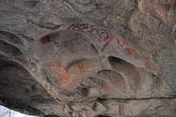
[1] The decorated rocks with white, black and red figures are pictures made approximately three thousand years ago, when various migratory flows penetrated the Baja California region, known as Yuman or Quechan, which came from what is now the United States.
[1] During ancient history, estimated at fourteen thousand years ago, early nomadic group arrived at the peninsula, through the Pacific Ocean shore routes, practising a subsistence economy.
[citation needed] There were three tribal groups perfectly defined during pre-Hispanic times: the Pericúes, Guaycuras and Cochimíes.
In parallel to the Cochimíes there were other nomad groups, such as Kumeyaay (K'miai), one of the native families that together with the Cucapá, Paipai, Kiliwa, Cahilla and Akula, occupied the northern part of Baja California.
Over time they divided into groups, each of which acquired certain territoriality, where they roamed in search of livelihood provided by natural resources.
[3] The Yumans or Quechan, ancestors of regional ethnic groups (Cucapá, Kiliwa, Pai-pai and Kumeyaay) were part of migratory flows to the Baja California peninsula from the north.
Upland Yuman consists of several mutually intelligible dialects spoken by the politically distinct Yavapai, Hualapai and Havasupai.
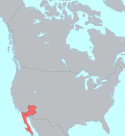
[citation needed] The Kumeyaay, also known as Tipai-Ipai, Kamia or formerly Diegueño, are Native American people of the extreme southwestern United States and northwest Mexico.
The two coastal groups' traditional homelands were approximately separated by the San Diego River: the northern Ipai (extending from Escondido to Lake Henshaw) and the southern Tipai (including the Laguna Mountains, Ensenada, and Tecate).
The general scholarly consensus recognizes three separate languages: Ipai, Kumeyaay proper (including the Kamia) and Tipai in northern Baja California (e.g., Langdon 1990).
This shelter is part of the rock wall, has a diminutive anthropomorphic figure in red with kind of antennas in the head, and beady black eyes.
This phenomenon is considered a solstice marker, indicating the start of winter in the northern hemisphere and served to mark a very special date in the Kumeyaay calendar.
[1][3] The “Indian cave” must have been particularly important for its residents, as it shows a lot of mortars, metates, ceramic material and lithic waste from making tools.
[1] Outstanding features are the profusion of elements in the walls and ceiling elaborated in various shades of red and black using natural rock formations.
Part of the set stands out as a rock with more than a dozen mortars and other small depressions or dimples with possible ritual functions, showing some visual balance in the forms displayed.