Emathia
Core samples and radiocarbon dating confirm that 19th and early 20th century literary analyses often had not taken into consideration changes in the terrain and the latest available archaeological data.
The deltas eventually combine to form alluvuial shelves and valleys, which, in the Aegean, typically became agricultural areas.
In the case of the C. Macedonian Plain, Bintliff combines geological data with historical sources to develop a brief history of shorelines there.
Geologists of the 19th and 20th centuries formulated a number of geologic models of the central Macedonian plain, but few were as useful those based on the excavation of Nea Nikomedeia (NN), 1961, 1963–64, under the direction of Rodden and Grahame Clark.
[2] NN is a Neolithic site at 40°36′15″N 22°15′54″E / 40.604156°N 22.264982°E / 40.604156; 22.264982, within the borders of Veria (Beroia), ancient capital of the Macedonian League, at the SW edge of the Plain.
In 1965 a core, subsequently named GIANNITB, taken by Sytze Bottema from the central area of the alluvium 7.5 km (4.7 mi) to the NW along a line to Gianitsa,[d] revealed a physically similar white clay layer, believed to be of the same surface.
It was clear that at some geologic time prior to the Neolithic the white layer had been deposited at the bottom of a lake and that it was continuous.
[8][f] The difference in altitude between the exposed settlement layer at NN and the bottom of the core is calculated at 7.5 m asl + 12 m bsl = 19.5 m (64 ft).
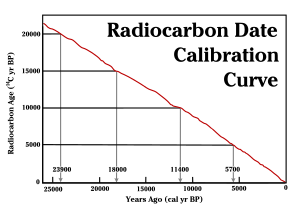
However, due to accidental factors not understood the readings may differ from the true values by logically consistent amounts.
To determine the amount of the correction the calibrator arbitrarily adjusts the readings to conform to test points known to be true.
Due to regular radioactive decay the amount of the now isolated isotope depends on the time since the cessation of interchange.
The 6.525 m date was 6590 ± 110 BP, which falls into the 6th millennium within the layer 6.58-6.8 m, described as "blue-grey clay," with an average depth of 6.69 m. The 9.950 m date was 7.27 ± 70 BP, which falls into the 8th millennium within the layer 9.74-10.91, described as "grey or blue-grey clay + shell fragments," with an average depth of 10.325 m. Bintliff's reconstruction of the early Plain of Central Macedonia is as follows.
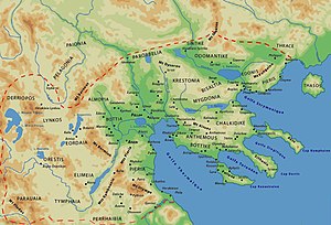
They led from the high country of the Balkans down into a region of sub-ridges next to the Thermaic Gulf that were beginning to subside along with the rest of the floor of the Aegean.
A brief review follows, starting from the SW of the wheel, moving CW, and ending on the SE, with the Thermaic Gulf as the exit notch.
[14] On the SW the upper Haliacmon River drains the east slopes of Mount Pindus on the southern border of Macedonia.
At points closer to the plain it flows to the north side of the Pierian Mountains, where it is dammed in a few places to impound reservoirs.
In the Late Pleistocene (129,000-11700 ya) through the Early Holocene (11650-8200 bp), the lake dried up, exposing the white layer, from which weathering removed the pollen.
In its place stands kato Makedonia, "Lower Macedonia," as it was when it was about to be attacked by Sitalces, Thracian king of the late 5th century BC.
These are the events described by Thucydides (Book II.99), considered their most credible narrator, because his account corresponds to that of Herodotus, their first author.
According to Thucydides, The Temenid Dynasty of Argos formed a new "country by the sea" by defeating tribal states arranged in a near-circle around the shores of what was then the Thermaic Gulf.
but Hera darted down and left the peak of Olympus; on Pieria she stepped and lovely Emathia, and sped over the snowy mountains of the Thracian horsemen, even over their topmost peaks, nor grazed she the ground with her feet; and from Athos she stepped upon the billowy sea, and so came to Lemnos, the city of godlike ThoasThe Homeric name was renewed mainly in Roman times and Ptolemy mentions some cities of Emathia.
In Ovid, Metamorphoses 5.313 the daughters of Pierus say: "we grant Emathia's plains, to where uprise Paeonia's peaks of snow".
In Fragment 5 of Catalogues he says:[23] And she [Thyia, daughter of Deukalion] conceived and bare to Zeus, the hurler of the thunderbolt, two sons, even Magnes and Makedon, rejoicing in horses, who had their dwellings around Pieria and Olympos.Homer does not mention Macedon, nor is there any word that might be interpreted as it in Linear B, but the Catalogue of Ships in the Iliad mentions that the Magnetes had moved away from Pieria (B756) before the Trojan War and were living in Magnesia.
[24] Herodotus has something more to say about Macedonia of the late 6th and following 5th centuries BC, when it makes its first major debut in history, thanks to the Persian invasion.
The story begins in Book V. Darius the Great had left an army in Thrace under his cousin Megabazus after his failed Scythian campaign of 513 BC with orders to reduce the region to satrapies.
He resolved to lead an army overland around the north of Greece, shadowed by and supported by a fleet keeping pace along the shore.
Xerxes crossed Thrace, marching inland of the coastal states that had been planted by peoples ejected by the Macedonians from Emathia, notably Piereis and Edoni.
They were forced to pay a heavy tribute in cash and goods by a suspicious king,(119) who did not offer any such terms to the Macedonians.
Seeing a major obstacle ahead, the Olympus-Pieria massifs, the king assembled his troops in Emathia with headquarters at Therma (early Thessalonika).
In this part of the account the term Macedonia does not appear; instead, Herodotus uses the Emathian kingdom names, even though they were now populated by Macedonian speakers.