Endeavour is an impact crater located in the Meridiani Planum extraterrestrial plain within the Margaritifer Sinus quadrangle (MC-19) region of the planet Mars.
The rim has become worn, rounded and degraded, with infilling of plains material in a manner similar to the Victoria crater.
[6] When compared to the surrounding plains, the crater floor shows an enhanced spectral signature of basalt and hematite.
[4] An informal working nickname by the Mars mission for the crater was Endeavour, and features of it, are based on the voyage of HM Bark Endeavour,[4] a British Royal Navy research vessel commanded by Lieutenant James Cook on his first voyage of discovery, to Fiji, New Zealand and Australia from 1769 to 1771, using Australian places named by James Cook.
[12] The purpose of the voyage was to observe the transit of Venus, to accurately measure the distance to the Sun, then to explore lands found on the return journey.
[13] An example of the difficulty of studying Mars features is also apparent with Orcus Patera, which has various volcanic, tectonic, or cratering events explanations for its formation.
[14] One famous Mars realization was that what was then called Nix Olympica was a volcano, and then renamed Olympus Mons thanks to Mariner 9 orbiter observations in the early 1970s.
[22][25] MER-B has had such new discoveries at the crater, that the rover team compared Endeavour to the equivalent of a second landing site for Opportunity.
"This is different from any rock ever seen on Mars," said Steve Squyres, principal investigator for Opportunity at Cornell University in Ithaca, New York.
[32][33][34] On March 7, 2009 (sol 1,820), Opportunity first imaged the rim of Endeavour after driving about 3.2 kilometers (2.0 mi) since it left Victoria in August 2008.
[8] On May 5, 2010, to avoid hazardous dune fields along the direct path between Victoria and Endeavour, the charted route between the two craters was extended to an estimated 19 kilometers.
[9] When it arrived it explored the northwest outcrops at Cape York (Mars) of the crater before heading south to Solander Point and the Western rim.
Endeavour as viewed from Mars orbit
The tip of the bottom right of the star is the approximate location of the crater Endeavour on Mars
Opportunity
images a Martian whirlwind on the floor of Endeavour (April 2016)
Colored for minerals.
Opportunity
traverse is dated to 2010 while it was still on its way to Endeavour. The coloring is based on geological information as observed by the
Mars Reconnaissance Orbiter
CRISM
instrument
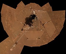
The crater Endeavour
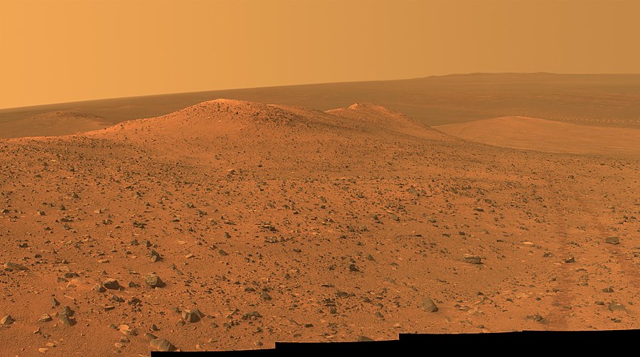
Western rim of the crater as seen from Cape York looking south, with the first ridge being Solander Point
Traverse map up to 4836 (September 12, 2017)
[
26
]
HiRise image from MRO, was laid over 3-D topographic map of the terrain, with 5-fold vertical exaggeration; view looking west on to Perseverance Valley on the western rim of Endeavour (February 15, 2018)
[
27
]
Arrival at Spirit Point at Endeavour, in the distance is the crater floor and on the other side the eastern rim segments
Eastern rim of Endeavour, the B&W swath is about 5 km across and the color swath 1 km
[
28
]
Part of the Eastern rim as seen by MER-B
Opportunity
'
s traverse up to March 2015 from its landing site to Endeavour. It has traversed south along the Western rim and orbiting spacecraft have help collect data on the rim, which in turn allows the rover to more closely investigate
Self-portrait of
Opportunity
near Endeavour on the surface of
Mars
(January 6, 2014).
Annotated image showing the May 2009 position of
Opportunity
and names for the craters Iazu, Endeavour, and Victoria
MER-B on Sol 2239 imaged the then distant crater rim. On this map several locations of Endeavour are identified including: Cape Tribulation, Cape Bryon, Cape Dromedary, Point Hicks, Torres Strait, and Batavia. Further south the nearby crater Iazu is also marked.
Here is the view from the rover's perspective from that location noted in the above top-down view. The white lines indicate the rover's
field of view
Opportunity
'
s traverse up to February 2015 as it approached Spirit of St. Louis Crater and Marathon Valley, and came close to traveling the distance of a traditional
marathon
(about 26 miles or 42 km)
Solander Point
Looking west in this topographic view overlaid photo, Solander is to the left, then moving right Botany Bay, and Cape York
"Homestake" vein
Wdowiak Ridge on the North-Western rim of Endeavour. MER-B recorded this panorama on Sept. 17, 2014 (Sol 3,786)
[
43
]
MRO Context Camera
images of
Schiaparelli
landing site; before (29 May 2016) and after (20 October 2016). The large black spot indicates the impact by the lander, and the white spot its parachute.
[
45
]
Endeavour can be seen on the right side of this map about halfway down; in the bottom left is the proposed landing ellipse for MSL in the crater Miyamoto.
A detailed-class rover traverse map by the mission, released on September 28, 2016, showing the track of the rover up to Sol 4500 as it heads deeper in Endeavour
An annotated view of the traverse to Spirit mound, October 2016
Opportunity
looks at the southern end of Cape Tribulation as it heads south, showing how the Western rim ridge
[
48
]
In March 2016, while trying to reach target on the slope of Marathon Valley in Cape Tribulation, the Mars rover attained a slope of 32 degrees, the highest angle yet for the rover since its mission began. This was so steep that dust that had accumulated on its top panels began to flow downward.
[
49
]
Above Perseverance Valley, July 2017
The proposed landing ellipse in Miyamoto when it was one of seven finalists under consideration as a landing site for MSL.
[
46
]
Endeavour can be seen on the right side of the map, the top of three medium-sized craters in a north–south line. This map is color-coded based on elevation.