Geography of Honduras
Honduras is the second largest Central American republic, with a total area of 112,777 square kilometres (43,543 sq mi).
[1] It follows the Río Coco near the Caribbean Sea and then extends southwestward through mountainous terrain to the Gulf of Fonseca on the Pacific Ocean.
[1] The soil here is poor: Honduras lacks the rich volcanic ash found in other Central American countries.
[1] This depression splits the country's cordilleras into eastern and western parts and provides a relatively easy transportation route across the isthmus.
[1] Widest at its northern end near San Pedro Sula, the depression narrows as it follows the upper course of the Río Humuya.
[1] The floors of the large valleys provide sufficient grass, shrubs, and dry woodland to support livestock and, in some cases, commercial agriculture.
[1] Subsistence agriculture has been relegated to the slopes of the valleys, with the limitations of small-sized holdings, primitive technology, and low productivity that traditionally accompany hillside cultivation.
[1] Much of the western, southern, and central mountains are open woodland; supporting pine forest interspersed with some oak, scrub, and grassy clearings.
[1] The central part of the Caribbean lowlands, east of La Ceiba, is a narrow coastal plain only a few kilometers wide.
[1] To the east and west of this section the Caribbean lowlands widen and in places extend inland a considerable distance along broad river valleys.
[1] Underpopulated and culturally distinct from the rest of the country, the area consists of inland savannah with swamps and mangrove near the coast.
[1] During times of heavy rainfall, much of the savannah area is covered by shallow water, making transportation by means other than a shallow-draft boat almost impossible.
The smallest geographic region of Honduras, the Pacific lowlands, is a strip of land averaging twenty-five km wide (16 mi) on the north shore of the Gulf of Fonseca.
[1] Both islands have volcanic cones more than 700 m (2,300 ft) in elevation that serve as landmarks for vessels entering Honduras's Pacific.
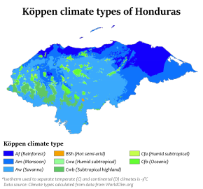
[1] The Caribbean lowlands have a tropical wet climate with consistently high temperatures and humidity, and rainfall fairly evenly distributed throughout the year.
Tegucigalpa, in a sheltered valley and at an elevation of 1,000 m (3,281 ft), has a pleasant climate, with an average high temperature ranging from 30 °C (86 °F) in April, the warmest month, to 25 °C (77 °F) in January, the coolest.
[1] Nearer San Pedro Sula, amounts are slightly less from November to April, but each month still has considerable precipitation.
[1] Total yearly amounts depend on surrounding topography; Tegucigalpa, in a sheltered valley, averages only 1,000 mm (39.4 in) of precipitation.
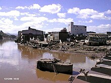
[1] Hurricane Francelia in 1969 and Tropical Storm Aletta in 1982 affected thousands of people and caused extensive damage to crops.
[6] This massive hurricane not only battered the Honduran coastline, but engulfed nearly the entire country with its powerful winds and torrential downpours.
[8] The high rainfall caused many rivers in the country to overflow "to an unprecedented extent this century", as described by the United Nations.
[9] The United Nations Economic Commission for Latin America and the Caribbean estimated that Mitch caused the worst floods of the 20th century in the country.
In November 2008, Hurricane Paloma, along with the October 2008 Central America floods, left at least 60 people dead and more than 300,000 in need of assistance.
[1] Lago de Yojoa, located in the west-central part of the country, is the sole natural lake in Honduras.
[1] The natural resources include: timbers, gold, silver, copper, lead, zinc, iron ore, antimony, coal, fish, and hydropower from the mountain rivers.
Frequent mild earthquakes, damaging hurricanes, and floods along the Caribbean coast are examples of Honduran natural hazards.
Deforestation poses a particular problem for Honduras; the goals of conserving endangered natural resources and promoting economic development has often been quite difficult to combine, which has resulted in conflicting policies that fail to protect forests.