Brazilian jurisdictional waters
From 1970 until it came into effect in 1994, Brazil had claimed a territorial sea as far as 200 nautical miles from the coast, instead of the present 12, but retains rights over natural resources in this area through its EEZ.
There is no official measurement of the Brazilian maritime economy;[7] 2015 estimates placed it at 2.67% of the gross domestic product directly tied to the sea, mostly in the tourism-dominated service sector.
[12] The territorial sea extends up to 12 nautical miles (22 kilometres) from baselines and grants coastal states sovereignty over the airspace, water column, seabed and subsoil.
[35][36][37] At the International Journal of Marine and Coastal Law, Alexandre Pereira Silva summarized in 2020 that the concept of AJB is incompatible with the UNCLOS and infringes on the freedom of the high seas.
[38] Tiago V. Zanella, an author on maritime law,[36] does not dismiss the concept's "enormous strategic importance" for the country,[39] but considers that to speak of jurisdictional rights over this area is to perform an "undue appropriation of a zone that is 'open to all states'".
Nonetheless, he contended that "the concept of AJB need not be changed", as it is already moderated in legislation by the expressions "jurisdiction, to some degree", "for the purposes of control and oversight" and "within the limits of national and international law".
[45] It is understood in multiple facets, that is, areas of interest to the state: sovereignty and national defense via political-strategic influence in the South Atlantic Ocean, economic prosperity, scientific and technological innovation and environmental conservation, with an emphasis on the first.
[58] This area has two international maritime boundaries, one with French Guiana and another with Uruguay, both of which are defined by rhumb lines (which cross the meridians at a constant angle) starting from the border: near the Oyapock River, for the former, and Chuí Lighthouse, for the latter.
[68] Contemporary international law defined no maximum width for the territorial sea, but in the early 1970s most states, including traditional maritime powers, recognized no jurisdiction beyond 12 nmi from the shore.
[51] Article 121 of UNCLOS confers an EEZ and continental shelf to islands, but denies such privileges to "rocks which cannot sustain human habitation or economic life of their own".
[81] However, Colombian representatives in a continental shelf dispute with Nicaragua pointed in 2019 that Brazil claims Rocas as an island and note the official Brazilian map has an EEZ projecting from the atoll.
[88] Starting on 1995, the Navy's Directorate of Hydrography and Navigation published nautical charts with a dotted red line in the 200 nmi radius around the rocks, indicating its potential EEZ and continental shelf.
[89] The Navy presented the Interministerial Commission on Marine Resources with its case in 1999, citing the precedents of Rockall, Okinotorishima, some Hawaiian islands, Clipperton, Jan Mayen and Aves.
[90] After securing approval from the president and the National Defense Council, in August 27, 2004 Brazil submitted the coordinates of the external limits of its EEZ to the UN's Bulletin of the Law of the Sea.
The Permanent Court of Arbitration ruled that "the mere presence of a small number of persons on a feature" that "is only capable of sustaining habitation through the continued delivery of supplies from outside" does not equate to island status under Article 121.
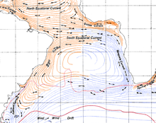
[101][100] The North Brazil Current achieves speeds of 1–2 m/s, pushing the Amazonas River's plume, which provides a fifth of the global fresh water discharge into the ocean, to the northwest.
[103][100] In the Southern and Southeastern regions, the Brazil Current draws closer and further from the coast throughout the year, defining a strong seasonal pattern in water temperature and salinity.
Easterly and northeasterly trade winds carry moisture from the coast and become colder and stronger in winter, from June to August, due to the South Atlantic High.
[113] Oceanographic and meteorological data are traditionally collected by ships, coastal stations and drifting or stationary buoys, which is labor-intensive to repeatedly monitor over large areas and time periods, but can be eased by satellites.
[126] On the other hand, 26.6% of the Brazilian population or 50 million inhabitants lived in the coastal zone's 450 thousand km2 as of the 2010 census,[127] a demographic density up to five times the national average.
The CIRM is coordinated by the Commander of the Navy, who is represented in the commission by an officer who also heads the Secretariat (SECIRM), a supporting organ which maintains contact with federal ministries, state governments, the scientific community and private entities.
[133][134] The Brazilian state invests in several research programs in the South Atlantic to shore up its continental shelf expansion proposals, ensure national presence in oceanic islands and understand the area's biodiversity and natural resources.
[140] Brazilian jurisdictional waters directly participate in the national Gross Domestic Product (GDP) in six sectors: services (particularly tourism), energy, manufacturing, defense, fishing and transport.
[171] National-flagged vessels couldn't compete after deregulation and the lifting of protectionist policies, and local shipbuilding costs remained higher than in other countries with greater labor and energy prices.
[154] Brazilian attractions in this sector are the vast coastline and internal waters, its climate and its scenery, with tropical and subtropical white sand beaches and, further south, coastal mountains.
[203] Fishing and aquaculture provide little more than 0.5% of national GDP, though they are relevant at the local level, creating 3.5 million direct and indirect jobs, mostly from artisanal fishermen and their families.
[206] Brazilian marine ecosystems are under pressure from industrial fishing, navigation, port and land pollution, coastal development, mining, oil and gas extraction, invasive species and climate change.
A particularly serious case was the Mariana dam disaster, which led to mining residues with a high concentration of iron, aluminum, manganese, arsenic, mercury and other metals crossing over 600 km through the Doce River until meeting the sea.
[209] Global ocean acidification may impede biogenic calficication in Espírito Santo and the Abrolhos Bank and dissolve existing shells and skeletons, releasing carbon dioxide.
[212] This measure allowed Brazil to announce its full implementation of Aichi Target 11, the protection of at least 10% of coastal and marine areas, which it had committed itself to fulfill in 2010, as a party to the Convention on Biological Diversity.