Explorer 22
Built at the Johns Hopkins University Applied Physics Laboratory,[4] under the direction of Goddard Space Flight Center.
The program will determine the total electron content of a vertical cross-section of the ionosphere located between the satellite and the earth.
Accomplishing this objective will aid in establishing the behavior pattern of the ionosphere as a function of latitude, time of day, season, and solar cycle".
[6] There was no tape recorder aboard so data could be received only when the satellite was within range of a ground telemetry station.
[3] Explorer 22 mounted 360 one-inch "cube corner" reflectors made of fused silica,[3] so that the satellite could be tracked via lasers beamed from mobile stations at Wallops Flight Facility (WFF).
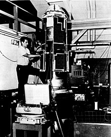
[5]: 346 [8] The Explorer S-66 had been constructed by March 1963, when a comprehensive series of environmental tests was begun to ensure the satellite could withstand the harsh conditions of space.
[11] Two coherent, unmodulated CW transmitters, operating on frequencies of 162 and 324 MHz, allowed the Tranet Doppler Network to obtain data for studies of dynamic geodesy.
The three lower frequencies underwent an appreciable number of rotations about the plane of polarization due to electron concentration.
Several methods were used to analyze these rotations and determine the total electron content between the satellite and a ground receiver.
[13] Explorer 22 involved the largest international participation to date in a NASA mission: some 50 scientific groups in 32 countries ran more than 80 ground tracking stations.
In July 1969, tracking and world map production were discontinued by Goddard Space Flight Center, and world map production based on NORAD orbit elements was subsequently assumed by European Space Research Organisation (ESRO).