Great Northern Highway
The highway, which travels through remote areas of the state, is constructed as a sealed, predominantly two-lane single carriageway, but with some single-lane bridges in the Kimberley.
Construction of a sealed road from Perth to Wyndham, including numerous bridges to reduce the impact of seasonal flooding, took many years to complete.
[1] Great Northern Highway travels to remote areas of Western Australia, including the Munjina Roadhouse near the Hamersley Ranges,[7] and the communities of Eighty Mile Beach, Wallal, Sandfire and Mandora, which are located between Broome and Port Hedland.
[8] Economically, Great Northern Highway is also a vital link in the resource rich regions of the Wheatbelt, Mid West, Pilbara, and Kimberley.
Tourism accounts for a significant portion of the road's traffic, and is a growing part of or potential growth source for the regional economies.
[16] Great Northern Highway begins at Morrison Road, Midland, in Perth's north-eastern suburbs, signed as National Route 1.
Great Northern Highway continues north for thirteen kilometres (8 mi) beyond West Swan Road, past larger agricultural properties, to reach Bullsbrook, the last urban area within the Perth Metropolitan Region.
After 11.5 kilometres (7 mi) beyond Bullsbrook, the highway reaches the edge of the Perth metropolitan area at the City of Swan–Shire of Chittering boundary, where it passes into the Wheatbelt.
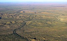
[19] In the Wheatbelt, Great Northern Highway links small town sites with the surrounding rural farmland, occasionally passing by remnant patches of woodlands.
It proceeds north to Marble Bar, mostly as an unsealed road, whilst the highway deviates north-west, reaching Newman after three kilometres (2 mi).
[25][26] From Pardoo, Great Northern Highway travels north-east, paralleling the coastline for 455 kilometres (283 mi), and passing Eighty Mile Beach near the Sandfire Roadhouse.
[1] The name Great Northern Highway was first proposed in October 1940 by the state's Nomenclature Advisory Committee,[a] to describe the main route from Midland to Geraldton, Western Australia.
[2] However, the highway was mostly a series of tracks through remote pastoral areas, with the sealed road ending just past the Wheatbelt town of Miling in 1950.
However, given the vast distance the highway travelled, and destructive cyclones in the Pilbara and Gascoyne that could destroy multiple weeks worth of work, the overall improvement was relatively insignificant.
[35]: 122 The 1961 Beef Roads Scheme initially included upgrading the Wyndham to Halls Creek section of Great Northern Highway as one of three projects in the region.
The route had been surveyed in 1979; with the collaboration of the Western Australian Museum, Main Roads ensured it would not impact important Aboriginal heritage sites.
The potential impacts on the natural environment, regional economy, tourism, and resident population were considered, with particular concern for the crossing of the Hamersley Range.
[35]: 362–5 As the highway would pass through the Hamersley National Park,[e] the Environmental Protection Authority decided in 1983 that an Environment Review and Management Program report was required for the Newman to White Springs section.
A detailed survey was carried out, which included the use of laser and infra-red measuring devices from within a helicopter, and numerous field trips to determine the final alignment and bridge sites.
The finished road was a scenic route curving down through the Munjina Gorge and out onto the Fortescue River flood plain, with cuttings and embankments blending it in with the natural environment.
[35]: 362–5 In the late 1960s, Main Roads investigated alternative crossing points over the Fitzroy River, to replace the existing low-level bridge at Yeeda.
[35]: 366 Four overtaking lanes were constructed between Mount Magnet and Cue in 1991; and between 1991 and 1993, there were eight contracts awarded to widen, reconstruct, and seal a combined total of more than 190 kilometres (120 mi) of the highway.
Modifications were made to the steep ascent of the Darling Scarp at Bindoon Hill between February 2002 and April 2003, and Great Northern Highway was realigned to bypass the Dalwallinu town centre.
[41] From 2005 to 2010, the Perth section, through the Swan Valley, was upgraded, with the road widened, turning and overtaking lanes constructed, and street lighting improved.
[42] Construction of a realignment around Port Hedland's Wedgefield industrial area, including a new parclo interchange at Wilson Street, began towards the end of 2012.
[51] Known as Muchea to Wubin Stage 2 Upgrade, the project continues work undertaken on this section from 2000 to improve the road to National Highway standards.
[65] Several bypasses, realignments, and other improvements have been planned at or near Muchea, Bindoon, New Norcia, Walebing, Miling, Pithara, Dalwallinu, Nugadong, and Wubin.
The project for widening and reconstruction works and improvements to road alignments on the Wyndham Spur was completed in mid 2019 at a total cost of $48.1 million.
[67] The project for widening and reconstruction works, including building a new bridge over Tickalara Creek is due to complete in late 2024 at a total cost of $43.5 million.
The project for widening, overlay and reconstruction works, including realigning 8 kilometres (5.0 mi) of road was completed in late 2019 at a total cost of $15.6 million.