Far North Region (Cameroon)
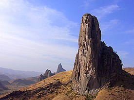
The Rhumsiki Valley, a mountainous field littered by the cores of extinct volcanoes, constitutes a small area of volcanic rock, such as trachyte and rhyolite.
The El Beid River flows northwest from the Kalamalou National Park and forms the northernmost stretch of the border between Cameroon and Nigeria.
The Mayo Tsanaga rises south and west of the El Béïd's source and moves eastward at the north of the Diamaré Depression.
This has caused some scientists to predict that in the future, river capture will occur, depriving Lake Chad of one of its major sources.
Beginning at 10° N, the climate is tropical and Sahelian, and rainfall is a relatively small 400 to 900 mm (16 to 35 in) per year, with rains falling a bit more frequently in the Mandara region.
These are further broken down based on average temperatures, yielding four distinct periods in the Sudan area: dry and relatively cool from November to January as the province experiences a shade of winter from climes further north, dry and hot from January to April, torrentially rainy from April to June, and cool and sporadically wet from June to November.
[3] The whole territory of the Far North Province was once home to most of Africa's iconic species: antelope, jackals, cheetahs, crocodiles, elephants, giraffes, heron, hippopotami, hyenas, leopards, lions, monkeys, warthogs, and others.
The frequently flooded Logone Valley and the perimeter of Lake Chad also support thicker and taller fields of grasses.
Human activities such as burning of fields, chopping down trees, and overgrazing of cattle have exacerbated the problem of desertification in the Far North.
[15] In larger towns and cities, such as Maroua, houses tend to follow the modern model of concrete walls and metal roof.
The head of a particular household or lineage often builds several small houses within a single, walled compound called a saré.
Another area of high density is the Mandara Mountains, a legacy of the Fulani conquest of the past, in the Diamaré plain, and at the Logone-Chari confluence and up to Lake Chad.
The Bororo Fulani, tall, thin nomads with lighter complexions than their sedentary kin, drive herds of cattle through this region, though they also move through most of the northern strip of land between Nigeria and Chad, as well.
Many of these Kirdi today live in the province's mountainous western border, as this areas was more easily defensible against the Fulani invaders.
The territory between Maroua, Mokolo, and Tokombére is a major population centre, and over a dozen ethnic groups live in small areas there.
Oudjilla has a picturesque chief's compound, and Tourou is renowned for the fact that the women there wear hats made from calabashes, which convey details such as marital status.
Human rights organisations cite Fulani lamibe (traditional rulers) as enjoying great leeway from the government, which allows them to keep private prisons and administer justice as they see fit.
The UNDP is largely Fulani-based today, but the ruling Cameroon People's Democratic Movement (CPDM) party is careful to address Fulani interests.
[38] Three cholera outbreaks have occurred in the Far North since 2010, in 2010, 2011, and 2014, as sanitation and access to clean drinking water became more difficult due to extended drought conditions.
The Shuwa Arabs, descendants of Banu Hilal deported from the Fatimid Caliphate in Egypt, arrived from the northeast and settled around Lake Chad in the 15th century.
[42] Archaeological finds attest to the existence of the Sao culture in the Logone valley and around Lake Chad as early as the 5th century.
They were eventually split, as the northern Kotoko became a vassal state of the Kanem Empire, while the southerners paid tribute but remained mostly independent with their capital at Logone-Birni.
Usman Dan Fodio declared a jihad in what is now northern Nigeria and Cameroon, and Modibo Adama led the charge into the land of Fumbina, which included areas of the Far North.
[47] The Fulani eventually came to rule the territory, with the exceptions of Mandara, Kotoko, and various Kirdi ethnic groups that had fled to the mountains and swamps.
Adama set up government over this new Adamawa Emirate in Yola (present-day Nigeria), answering only to the sultan of the Sokoto Empire.
The Mandara Mountains and the swampy confluence of the Logone and Chari rivers supported the highest population density, as many peoples had fled the Neo-Sudanese and Fulani invasions by taking refuge on higher ground.
Denham accompanied the Bornu and Mandara army in its attack on Fulani in Mosfei, north of Maroua in April 1823.
The others arrived at the Mandara Mountains and then explored Uba, the northernmost Fulani settlement in the Adamawa Emirate then continued on to Yola.
[54] Missionaries began to arrive, setting up a Bible school at Yagoua and a printing press for religious literature in Kaélé.
"[56] In December 2021, dwindling of water resources around Lake Chad led to clash between Arab Choa herders and Mousgoum and Massa farmers.