Far North Queensland
Its largest city is Cairns and it is dominated geographically by Cape York Peninsula, which stretches north to the Torres Strait, and west to the Gulf Country.
The waters of Torres Strait include the only international border in the area contiguous with the Australian mainland, between Australia and Papua New Guinea.
The Queensland Government department of Trade and Investment Queensland defines the region as an area comprising the following 25 local government areas; Aurukun, Burke, Cairns, Carpentaria, Cassowary Coast, Cook, Croydon, Doomadgee, Douglas, Etheridge, Hope Vale, Kowanyama, Lockhart River, Mapoon, Mareeba, Mornington, Napranum, Northern Peninsula Area, Pormpuraaw, Tablelands, Torres Strait Islands (not autonomous), Torres Strait Islands (autonomous), Weipa, Wujal Wujal, and Yarrabah.
Other key population centres include Cooktown, the Atherton Tableland, Weipa, Innisfail and the Torres Strait Islands.
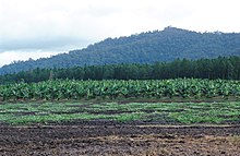
[2] Significant industries include tourism, cattle grazing, agriculture and mining of both sand and bauxite.
[3] Sugar cane, tropical fruits including bananas, mangoes, papaya, lychees and coffee are grown in Far North Queensland.
The region supports a large tourism industry and is considered a premier tourist destination in Australia.
Towns and localities attracting large numbers of tourists include Cape Tribulation, Port Douglas, Mission Beach and Cardwell.
The language region includes areas within the local government area of Shire of Douglas and Shire of Cook, particularly the localities of Mossman, Daintree, Bloomfield River, China Camp, Maytown, Palmer, Cape Tribulation and Wujal Wujal.
The four-million-year-old fossils were found on a beach in Cape York Peninsula but were probably washed ashore after drifting with the currents for about 200 km.
[14] In the 1860s, Richard Daintree discovered gold and copper deposits along several rivers which led early prospectors to the area.
[17] The region suffered Queensland's worst maritime disaster on 4 March 1899 when the Mahina Cyclone destroyed all 100 ships moored in Princess Charlotte Bay.
[19] The 1918 Mackay cyclone hit the Queensland coast in January of that year, killing 30 people.
It later stalled over the southern York Peninsula resulting in record rainfall along the eastern coast that lead to the 2023 Cairns floods.
[21] The region has many unique native animal species such as crocodile, endangered southern cassowary, koala, flying possum, python, water dragon, wallabie, flying fox, tree kangaroo, platypus, leaf-tailed gecko and bandicoot.