South East Queensland
Its most common use is for political purposes, and covers 35,248 square kilometres (13,609 sq mi)[6] and incorporates 11 local government areas,[2] extending 240 kilometres (150 mi) from Noosa in the north to the Gold Coast and New South Wales border in the south (some sources include Tweed Heads, New South Wales which is contiguous as a conurbation with Brisbane/Gold Coast), and 140 kilometres (87 mi) west to Toowoomba (which is simultaneously considered part of the Darling Downs region).
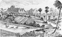
Settlements initially arose in the Brisbane and Ipswich areas with activity by European immigrants spreading in all directions from there.
The economy of South East Queensland supports and relies on a wide diversity of agricultural manufacturing industries, commerce and tourism.
[8] Early explorers in the area including Matthew Flinders, Allan Cunningham, John Oxley and Patrick Logan.
While not officially part of the Translink public transport network, Kinetic Group run a seamless service across the border that appears to passengers as though it is integrated.
Some geographers suggest several more master-planned communities will be needed to cater for the expected population growth rates.
[14]The region exports a number of crop products including broccoli, onion, Chinese cabbage, sweet corn and celery.
Timber cutting, mining and a range of agricultural pursuits including dairying were once prominent in South East Queensland.
Tourism, in part due to Brisbane serving as major transport and export hub and destinations such as the Gold Coast and the availability of land for industry, has grown in recent decades together with specialised skills in professional services and manufacturing.
[16] Car dependency has a risen when the location of jobs in areas such as health and education are at distance from where the majority live.
[17] As of 2014, the population of South East Queensland is estimated to be approximately 3.4 million, meaning that between one in six and one in seven Australians call the region home.
[29] The regional plan covers the period from 2009–2031 and focuses on slowing development along the coast, in order to prevent creating a 200 km city, and instead aim for growth in the west, in particular around Springfield and Beaudesert.
[29] Infrastructure planning in South East Queensland is almost exclusively designed to facilitate trans-metropolitan travel and reduce traffic congestion.
The Lockyer Valley, a major agricultural area referred to as "South East Queensland's Salad Bowl", lies outside Brisbane.
In South East Queensland the koala is threatened by habitat loss, disease such as chlamydiosis[32] and increased mortality due to domestic animals and motor vehicles.
In 2022, 60 new suburbs around Brisbane, Moreton Bay, and the Scenic Rim were added to the biosecurity zone as part of a national fire ant eradication program.