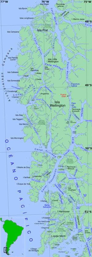
Fjords and channels of Chile
The southern coast of Chile presents a large number of fjords and fjord-like channels from the latitudes of Cape Horn (55° S) to Reloncaví Estuary (42° S).
The earliest known inhabitants of the fjords and channels were, from north to south, the Chono, Alacalufe and Yaghan, all of whom shared a life style as canoe-faring hunter-gatherers.
[2] It is often assumed that Chonos were the people who left behind most of the abundant Pre-Historic shell middens (chonchales) of Chiloé Archipelago, yet this claim is unverified.
[3] Guaitecas Archipelago made up the southern limit of Pre-Hispanic agriculture[4] as noted by the mention of the cultivation of potatoes by a Spanish expedition in 1557.
[7] Indeed, even in Chiloé did the Spanish encounter difficulties to adapt as their attempts to base the economy on gold extraction and a "hispanic-mediterranean" agricultural model failed.
[9] Following the decline of the Chono populations in the archipelago in the 18th century, the area gained a reputation of "emptiness" among Chileans akin to the description of eastern Patagonia as a "desert.
[14] During his explorations and charting in the second half of the 19th century Vidal Gormaz became critical of the work of Robert FitzRoy and Charles Darwin whom according to him had failed acknowledge the importance of the Patagonian islands.
[11] Felipe Westhoff, a German-Lithuanian immigrant who operated a Pilgerodendron uviferum logging business from Ancud, founded Melinka in Guaitecas Archipelago in 1860.
[18][11][19] Álvarez business owned him the nickname of "The King of Pilgerodendron" (Spanish: El Rey del Ciprés)[17] and had great effects on the incipient economic development that came to link the archipelagoes of Chiloé, Guaitecas and Chonos.
[20][21] Navigating through the fjords and channels of Chile is mostly done by vessels desiring to avoid the heavy seas and bad weather so often experienced on passing into the Pacific Ocean from the western end of the Strait of Magellan.
The large full-powered mail steamers generally at once gain the open sea at Cape Pillar (at the west entrance of the Strait of Magellan), as experience has shown that time is thus saved to them; but vessels of less engine power, to which punctuality and dispatch is not so much an object as avoiding possible danger, will find the Patagonian Channels the best route.
The general features of these channels are high, abrupt shores, with innumerable peaks and headlands remarkably alike in character, their bold, rugged heads giving an appearance of gloomy grandeur rarely seen elsewhere.
Since it is impossible to reach all the region by road through Chile, the transport of persons and cargo must be done by ship or airplanes according to the public infrastructure provision.
[25] Cruise ships also operate between the main ports of the region and offer a journey that is considered an experience in itself, due to the slow way of entering this magnificent landscape of narrow channels and solitary islands.