Flood management
Flooding can be caused by a mix of both natural processes, such as extreme weather upstream, and human changes to waterbodies and runoff.
However, it is best practice within landscape engineering to rely more on soft infrastructure and natural systems, such as marshes and flood plains, for handling the increase in water.
Floods are caused by many factors or a combination of any of these generally prolonged heavy rainfall (locally concentrated or throughout a catchment area), highly accelerated snowmelt, severe winds over water, unusual high tides, tsunamis, or failure of dams, levees, retention ponds, or other structures that retained the water.
Flooding can be exacerbated by increased amounts of impervious surface or by other natural hazards such as wildfires, which reduce the supply of vegetation that can absorb rainfall.
During times of rain, some of the water is retained in ponds or soil, some is absorbed by grass and vegetation, some evaporates, and the rest travels over the land as surface runoff.
Property owners may fit their homes to stop water entering by blocking doors and air vents, waterproofing important areas and sandbagging the edges of the building.
[19] Flood mitigation at the property level may also involve preventative measures focused on the building site, including scour protection for shoreline developments, improving rainwater in filtration through the use of permeable paving materials and grading away from structures, and inclusion of berms, wetlands or swales in the landscape.
Defenses (both long-term and short-term) can be constructed to minimize damage, which involves raising the edge of the water with levees, embankments or walls.
One way of reducing the damage caused by flooding is to remove buildings from flood-prone areas, leaving them as parks or returning them to wilderness.
Floodplain buyout programs have been operated in places like New Jersey (both before and after Hurricane Sandy),[22] Charlotte, North Carolina,[23] and Missouri.
[24] In the United States, FEMA produces flood insurance rate maps that identify areas of future risk, enabling local governments to apply zoning regulations to prevent or minimize property damage.
[38] These methods include planting vegetation to retain extra water, terracing hillsides to slow flow downhill, and the construction of floodways (man-made channels to divert floodwater).
[38] Other techniques include the construction of levees, lakes, dams, reservoirs,[38] retention ponds to hold extra water during times of flooding.
Many large dams have flood-control reservations in which the level of a reservoir must be kept below a certain elevation before the onset of the rainy/summer melt season to allow a certain amount of space in which floodwaters can fill.
It is being used in California, where orchards and vineyards can be flooded without damaging crops,[48] or in other places wilderness areas have been re-engineered to act as floodplains.
Two such weirs, the first in the UK, were installed on the River Aire in October 2017 at Crown Point, Leeds city centre and Knostrop.
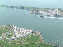
A surge barrier is almost always part of a larger flood protection system consisting of floodwalls, levees (also known as dikes), and other constructions and natural geographical features.
Eight foot tall water filled barriers were used to surround Fort Calhoun Nuclear Generating Station during the 2011 Missouri River Flooding.
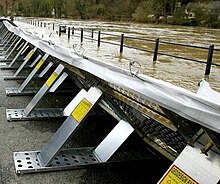
[51] AquaFence consists of interlocking panels which are waterproof and puncture-resistant, can be bolted down to resist winds, and use the weight of floodwater to hold them in place.
These can involve policies that reduces the amount of urban structures built around floodplains or flood prone areas through land zoning regulations.
[64] Flood mapping has been criticized in many areas around the world, due to the absence of public accessibility, technical writing and data, and lack of easy-to-understand information.
[75] After Hurricane Sandy, New York City's Metropolitan Transportation Authority (MTA) initiated multiple flood barrier projects to protect the transit assets in Manhattan.
[78][79] In the New Orleans Metropolitan Area, 35 percent of which sits below sea level, is protected by hundreds of miles of levees and flood gates.
In assessing the impacts of Himalayan deforestation on the Ganges-Brahmaputra Lowlands, it was found that forests would not have prevented or significantly reduced flooding in the case of an extreme weather event.
[83] However, more general or overview studies agree on the negative impacts that deforestation has on flood safety - and the positive effects of wise land use and reforestation.
[90] Rotterdam started a project to construct a floating housing development of 120 acres (0.49 km2) to deal with rising sea levels.
[91] Several approaches, from high-tech sensors detecting imminent levee failure to movable semi-circular structures closing an entire river, are being developed or used around the world.
Natural sand dunes and constructed dikes, dams, and floodgates provide defense against storm surges from the sea.
Flooding is the greatest natural hazard in New Zealand (Aotearoa),[93] and its control is primarily managed and funded by local councils.
[94] Throughout the country there is a network of more than 5284 km of levees,[95] while gravel extraction to lower river water levels is also a popular flood control technique.