Floodplain
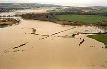
Floodplains stretch from the banks of a river channel to the base of the enclosing valley, and experience flooding during periods of high discharge.
This can encourage farming;[4] some important agricultural regions, such as the Nile and Mississippi river basins, heavily exploit floodplains.
Agricultural and urban regions have developed near or on floodplains to take advantage of the rich soil and freshwater.
The overall effect is that, as the river meanders, it creates a level flood plain composed mostly of point bar deposits.
Flow over the banks of the river deposits a thin veneer of sediments that is coarsest and thickest close to the channel.
In undisturbed river systems, overbank flow is frequent, typically occurring every one to two years, regardless of climate or topography.
[8] Sedimentation from the overbank flow is concentrated on natural levees, crevasse splays, and in wetlands and shallow lakes of flood basins.
Natural levees are ridges along river banks that form from rapid deposition from the overbank flow.
[10] Repeated flooding eventually builds up an alluvial ridge, whose natural levees and abandoned meander loops may stand well above most of the floodplain.
Extreme drying can destroy the ability of the floodplain ecosystem to shift to a healthy wet phase when flooded.
[18] Flood control creates a sharper boundary between water and land than in undisturbed floodplains, reducing physical diversity.
Tropical rivers are less impacted by humans and provide models for temperate floodplain ecosystems, which are thought to share many of their ecological attributes.
This had been preceded by the 1887 Yellow River flood, which killed around one million people and is the second-worst natural disaster in history.
The extent of floodplain inundation depends partly on flood magnitude, defined by the return period.
A large shopping center and parking lot, for example, may raise the levels of 5-year, 100-year, and other floods, but the maps are rarely adjusted and are frequently rendered obsolete by subsequent development.
[26] Many State and local governments have, in addition, adopted floodplain construction regulations which are more restrictive than those mandated by the NFIP.
In some floodplains, such as the Inner Niger Delta of Mali, annual flooding events are a natural part of the local ecology and rural economy, allowing for the raising of crops through recessional agriculture.
However, in Bangladesh, which occupies the Ganges Delta, the advantages provided by the richness of the alluvial soil of the floodplain are severely offset by frequent floods brought on by cyclones and annual monsoon rains.
These extreme weather events cause severe economic disruption and loss of human life in the densely-populated region.
Floodplain forests generally experience alternating periods of aerobic and anaerobic soil microbe activity, affecting fine root development and desiccation.
[34] Wet/dry cycling within the floodplain greatly impacts phosphorus availability because it alters water level, redox state, pH, and physical properties of minerals.
[39] In basins where SRP is the primary form of phosphorus, biological uptake in floodplain forests is the best way of removing nutrients.
[41] Floodplain soils tend to be high in eco-pollutants, especially persistent organic pollutant (POP) deposition.