Floods in Bangladesh
Due to being part of such a basin and being less than 5 meters above mean sea level, Bangladesh faces the cumulative effects of floods due to water flashing from nearby hills, the accumulation of the inflow of water from upstream catchments, and locally heavy rainfall enhanced by drainage congestion.
Coastal flooding, combined with the bursting of river banks is common, and severely affects the landscape and society of Bangladesh.
80% of Bangladesh is floodplain,[1] and it has an extensive sea coastline,[2] rendering the nation very much at risk of periodic widespread damage.
Whilst more permanent defenses, strengthened with reinforced concrete, are being built, many embankments are composed purely of soil and turf and made by local farmers.
Small scale flooding in Bangladesh is required to sustain the agricultural industry, as sediment deposited by floodwaters fertilises fields.
The water is required to grow rice, so natural flooding replaces artificial irrigation, which is time-consuming and costly to build.
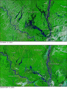
The catastrophic floods of 1987 occurred throughout July and August[6] and affected 57,300 square kilometres (22,100 sq mi) of land, (about 40% of the total area of the country) and was estimated as a once in 30-70 year event.
The waters inundated about 82,000 square kilometres (32,000 sq mi) of land, (about 60% of the area) and its return period was estimated at 50–100 years.
A combination of heavy rainfall within and outside the country and synchronisation of peak flows of the major rivers contributed to the flood.
Few hospitals were functional because of damage from the flooding, and those that were open had too many patients, resulting in everyday injuries becoming fatal due to lack of treatment.
In 2017, unpredicted early heavy rain caused flooding in several parts of Bangladesh and damaged pre-harvested crops in April.
The April flood continued until the last week of August and caused substantial damage to housing, property, and infrastructure.
There needs to be serious considerations to mitigate the effects of climate change and invest in capacity building of each system component to secure the future of this country.
The overall damage:Yearly flooding during monsoon season and other forms of inclement weather have forced the people of Bangladesh to adjust their lifestyle in order to prepare for the worst.
[14] Additionally, organisations such as the Global Fund for Children and the Bill & Melinda Gates Foundation have taken the initiative of helping kids rebuild their lives after natural disasters by building schools that function on boats themselves.
"Floating schools", as these classrooms are known, help provide an education for children whose lives were drastically affected by the effects of constant flooding.
[14] As a result of several demanding summer floods, in 2004, the government of Bangladesh made the step of seeking foreign aid rather than try to assist the millions of homeless people on their own.
Nearly all the 147 million people living in Bangladesh at the time (crammed into a space the size of Iowa) were forced to adapt to intense rainfall and water-borne disease exposed conditions.
In this case, remote sensing and geographic information system can play a vitally important role in finding suitable locations for flood shelters.