Ford Island
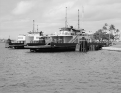
[5] It connects to the larger island of Oʻahu, surrounding Pearl Harbor, via a 4,672 ft (1,424 m) bridge at its northern tip that crosses east to Halawa Landing.
[22] Those selected for ʻume (never virgins or the unmarried) would sing around a large bonfire while a tribal leader with a maile (wand) chanted, touching individual men and women.
[24] Kaʻahupa-hau's brother Kahiʻuka (sometimes referred to by historians as her son, Ku-maninini) was said to live in an underwater cavern off Ford Island[25] with Kanekuaʻana, a giant water lizard which supplied food to the people of ʻEwa Beach.
[15][16] The business was successful, and the company sublet land from Benjamin Dillingham on the Waipi'o peninsula (southeast of present Waipio) to build a 12-roller mill and railroad.
[43] Sugarcane was grown and harvested on Ford Island with a network of aqueducts from freshwater reservoirs, transported to Waipio by barge and then by rail to the mills.
[43] In 1902, the nearby estate of Bernice Pauahi Bishop lost a crucial lawsuit brought by the United States to purchase land around Pearl Harbor for below its market value.
[44] Facing a similar lawsuit and interest in its land on Ford Island, the John Papa ʻĪʻī estate settled with the United States to deed twenty-five acres at no cost.
[30][45] In 1917, the John Papa ʻĪʻī estate agreed to sell part of the Island to the United States for construction of an airfield,[16] despite the Oahu Sugar Company complaining in court that the sale would hurt their business.
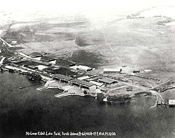
[46] Currey chose Ford Island as the location for the new squadron and bought it from the John Papa ʻĪʻī land trust for $236,000, citing its access to water and winds as assets.
[54][55] Kirk-Patrick's men had two Curtiss HS2L flying boats and two N-9 planes salvaged from World War I, which they stored in two large canvas hangars across the harbor from the island.
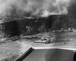
[65] Ford Island was the headquarters of Patrol Wing Two, an important target for the first-wave airborne raiders in the December 7, 1941, Japanese attack on Pearl Harbor.
[69] 1: California 2: Maryland 3: Oklahoma 4: Tennessee 5: West Virginia 6: Arizona 7: Nevada 8: Pennsylvania 9: Ford Island NAS 10: Hickam Field A: Oil storage tanks
C: Submarine base D: Naval yard The initial bombs struck the island at 07:57 local time, prompting the historic dispatch: "Air Raid, Pearl Harbor—this is no drill.
[69] The planes carried 29 Type 91 aerial torpedoes, each with a high-explosive payload of 450 pounds (200 kg), of which 12 are thought to have found their targets: two in California, one in Nevada and a possible total of nine in Oklahoma and West Virginia; the latter two ships sank within minutes of being hit.
[69] Several planes from the aircraft carrier Enterprise, near Hawaii after a mission to Wake Island, arrived in the midst of the attack; four were shot down by American air-defense friendly fire.
[72][73] After attempting to notify as many ships and anti-aircraft batteries as possible, several planes from Enterprise and others from Ford Island's complement were again airborne within hours to search for the attackers.
[78] Five American pilots returning from missions to hunt down the Japanese fleet were mistakenly shot down by Ford Island anti-aircraft gunners while attempting to land.
[80] That evening, Hawaiians were instructed to observe an indoor blackout,[78] stay off the telephone, keep extra buckets of water available for fighting fires and keep cars off the streets (parking them on lawns, if necessary).
[76] The entire salvage operation took 20,000 man-hours underwater and 5,000 dives to recover human remains, weapons, ammunition and artifacts of historic or military importance.
[54][84] On February 20, 1970, the 4,000-foot (1,200 m) runway at NALF Ford Island was opened to civilian flight training operations, primarily local Army, Navy, Air Force and Marine Corps flying clubs.
[90][91][92][93] It connected 45 families and 3,000 civilian workers to Kamehameha Highway,[85] and visitor access enabled construction of the $50 million 16-acre (6.5 ha) Pacific Aviation Museum.
[96] However, the National Trust for Historic Preservation considered the Navy's communication style more directive rather than collaborative, restricting the NTHP's ability to share their concerns, and in 2001 designated Ford Island one of its 11 most-endangered sites.
[97] In 2005, the Navy contracted drilling for primary and auxiliary conduits 20 feet (6.1 m) apart and parallel to the bridge from Halawa Landing to the Ford Island golf course.
[97] In June 2013 the Navy planned to install 60,000 photovoltaic panels over 28 acres (11 ha) on the Ford Island runway,[99] to comply with Congressional and Defense Department mandates to reduce dependence on fossil fuels and offset the cost of Hawaiian energy (the highest in the United States).
The museum declined,[100] organizing an internet campaign opposing the plan based on the runway's historic significance and highlighting Ford Island's role in the attack on Pearl Harbor and Amelia Earhart's visit.
[101] The Admiral Clarey Bridge enabled the Navy to develop a $331 million Pacific tsunami warning center named after Senator Daniel Inouye, replacing the aging facility on ʻEwa Beach.
[106][108] In 2013, the Navy unveiled a $4-million training facility, using simulators and virtual reality, at the Naval Undersea Warfare Center Division Keyport on Ford Island.
[120] The Pacific Aviation Museum Pearl Harbor signed a lease with the US Navy on September 2, 2010, for the Ford Island control tower, which sent the first radio alert of the attack, and began its restoration.
[122] A Boeing B-17 Flying Fortress used in the production experienced a landing-gear malfunction and crash-landed on Ford Island, and the crash landing was included in the film.
[128] The episode, with police cars racing down Tennessee and Nevada Streets, featured a number of Ford Island homes and some residents appeared as extras.