Marine Corps Base Hawaii
[not verified in body] The base lies between the two largest windward O'ahu communities of Kailua and Kāne'ohe, and the main gate is reached at the eastern end of Interstate H-3.
MCB Hawaii is located on the windward side of Oahu, approximately 12 miles (19 km) northeast of Honolulu.
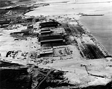
Marine Corps Base Hawaii occupies the entire Mokapu Peninsula, an area of 2,951 acres (1,194 ha; 11.94 km2).
[not verified in body] In 1918, President Woodrow Wilson designated 322 acres (130 ha; 1.30 km2) of land on Mokapu Peninsula for the military.
MCAS Kaneohe Bay, Camp H. M. Smith, Molokai Training Support Facility, Manana Family Housing Area, Puuloa Range, and the Pearl City Warehouse Annex combined to form a new command, the Marine Corps Base Hawaii, headquartered at MCBH Kaneohe Bay.
The Commanding General of Marine Forces Pacific (MARFORPAC) also commands 12 Marine Corps bases and stations in Arizona, California, Hawaii, and Japan, operational forces in Hawaii and Okinawa Prefecture, and units deployed to Southeast/west Asia.
The plane was from Patrol Squadron 4 ("Skinny Dragons") based at Naval Air Station Whidbey Island in Washington state.
[This paragraph needs citation(s)]It is dominated by two large volcanic formations, Radar Hill and Ulapau Crater.
[9] The Hawaii Department of Education operates Mokapu Elementary School on the MCBH property which goes from kindergarten to 6th grade.