Former administrative divisions of Romania
The earliest organization into județe of the Principalities of Wallachia, respectively ținuturi of Moldavia, dates back at least to the late 14th century.
[1] Each județ, respectively ținut, was ruled by a jude, respectively pârcălab, an officially appointed person who had administrative and judicial functions in a manner inspired from the organization of the late Byzantine Empire.
Transylvania, when it was part of the historic Kingdom of Hungary (in the Middle Ages), an independent Principality or a Habsburg domain (in the modern era until World War I) was divided into royal counties (Latin: comitatus), headed by comes (royal counts) with administrative and judicial functions.
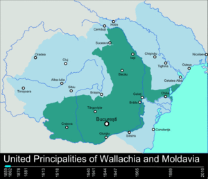
When modern Romania was formed in 1859 through the union of Wallachia and rump Moldavia, and then extended in 1918 through the union of Transylvania, as well as Bukovina and Bessarabia (parts of Moldavia temporarily acquired by respectively the Habsburgs, 1775–1918, and the Russian Tsars, 1812–1917), the administrative division was modernized using the French departments system as model.
Until 1950, each județ was divided into a number of plăși (singular plasă), each administered by a pretor (from the Latin praetor), appointed by the prefect.
As in all modern democracies, the political power in Romania is divided into three independent branches: legislative, executive, and judicial.
[4] In 1923 Romania adopted a new Constitution, and it unified the traditional administrative systems of Transylvania, Bukovina and Bessarabia with that of the Romanian Old Kingdom.
The latter ones are: As a part of King Carol II's administrative reform of August 14, 1938, 10 regions (ținuturi) were created, which each included several of the existing 71 counties.
It included the counties of Bălți, Cetatea Albă, Cahul, Chilia (newly established), Ismail, Lăpușna, Orhei, Soroca and Tighina.
This territory was administered by Romania briefly in 1941–1944, when the country was governed by a military dictatorship allied with Nazi Germany.
In 1940, Soviet Union occupied Bessarabia, northern Bukovina, and the Hertsa region (the latter part of Dorohoi County in a rump Moldavia).
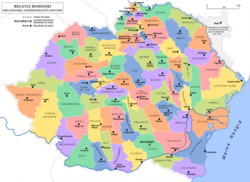
[10] In 1952 the number of regions was reduced to 18: Arad, Bacău, Baia Mare, Bârlad, București, Cluj, Constanța, Craiova, Galați, Hunedoara, Iași, Oradea, Pitești, Ploiești, Stalin, Suceava, Timișoara, and for the first time and autonomous administrative unit based on ethnic criteria, Magyar Autonomous Region (Regiunea Autonomă Maghiară).
The county borders introduced in 1968 are largely in place at present, but administrative reforms during the 1990s have devolved the functions of different authorities in line with transition from a totalitarian communist system to a modern democracy.
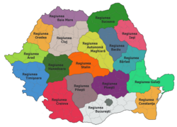
As of 2010–2011 there have been several proposals for the administrative reorganization of Romania made by the presidential commission tasked with the analysis of the current political and constitutional system.
If this reform were adopted, the counties would be grouped into several regions (9 to 15) based on common historical and economic characteristics (NUTS II level).
Furthermore, a NUTS IV level division, called plasă or canton, would probably be added in order to meet the EU statistical and administrative requirements.