Franz Josef Land
The archipelago was first spotted by the Norwegian sailors Nils Fredrik Rønnbeck and Johan Petter Aidijärvi in 1865, although they did not report their finding.
The first reported finding was in the 1873 Austro-Hungarian North Pole expedition led by Julius von Payer and Karl Weyprecht, who named the area after Emperor Franz Joseph I.
In 1926, the Soviet Union annexed the islands, which were known at the time as Fridtjof Nansen Land, and settled small outposts for research and military purposes.
It was at the time common to keep newly discovered areas secret, as their discovery was aimed at exploiting them for sealing and whaling, and exposure would cause competitors to flock to the site.
[2] Russian scientist N. G. Schilling proposed in 1865 that the ice conditions in the Barents Sea could only be explained if there was another land mass in the area, but he never received funding for an expedition.
[4] Starting in July 1872,[5] the vessel drifted from Novaya Zemlya to a new landmass,[6] which they named in honor of Franz Joseph I (1830–1916), Emperor of Austria.
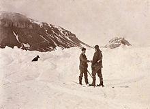
Departing in 1893, Fram drifted from the New Siberian Islands for one and a half years before Nansen became impatient and set out to reach the North Pole on skis with Hjalmar Johansen.
[14] By pure chance, at Cape Flora in the spring of 1896, Nansen stumbled upon Frederick George Jackson, who was able to transport him back to Norway.
[12] Once the basic geography of Franz Josef Land had become apparent, expeditions shifted to using the archipelago as a basis to reach the North Pole.
[15] The two Norwegians, Paul Bjørvig and Bernt Bentsen, stayed the winter 1898–9 at Cape Heller on Wilczek Land, but insufficient fuel caused the latter to die.
The expedition was largely regarded as an utter failure by the exploration and scientific community, which cited the lack of proper management.
Among its scientific contributions were the first snow measurements of the archipelago, and the determination that changes of the magnetic field occur in cycles of fifteen years.
The world's first Arctic flight took place in August 1914, when Polish aviator (one of the first pilots of the Russian Navy) Jan Nagórski overflew Franz Josef Land in search of Sedov's group.
[29] Norway attempted both a diplomatic solution and a Lars Christensen-financed expedition to establish a weather station to gain economic control over the islands, but both failed in 1929.
[30] Instead the Soviet icebreaker Sedov set out, led by Otto Schmidt, landed in Tikhaya Bay, and began construction of a permanent base.
[32] Except for a German weather station emplaced during the Second World War, these were the last Western expeditions to Franz Josef Land until 1990.
In 1934–35 geological and glaciological expeditions were carried out, cartographic flights were flown, and up to sixty people stayed the winters between 1934 and 1936, which also saw the first birth.
With the advent of intercontinental ballistic missiles, the Soviet Union changed its military strategy in 1956, abolishing the strategic need for an airbase on the archipelago.
[41] As part of the opening up of Franz Josef Land, the Institute of Geography in Moscow, Stockholm University and Umeå University (Sweden) conducted expeditions to Alexandra Land in August 1990 and August 1991, studying climate- and glacial history by radiocarbon dating raised beaches and antlers from extinct caribou.
[46] In 2011, in a move to better accommodate tourism in the archipelago, the Russian Arctic National Park was expanded to include Franz Josef Land.
Cape Flighely, situated at 81°50′ north, is the northernmost point in Eurasia and the Eastern Hemisphere,[54] and of either Europe or Asia, depending on the continental definition.
[57] Geologically the archipelago is located on the northern edge of the Barents Sea Platform, within an area where Mesozoic sedimentary rocks are exposed.
Plate tectonics of the Arctic Ocean created basalt lavas and dolerite sheets and dykes in the Upper Jurassic and Lower Cretaceous periods.
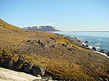
[60] Franz Josef Land is dominated by glaciation, which covers an area of 13,735 square kilometers (5,303 sq mi), or 85 percent of the archipelago.
The ice coverage starts to decrease in May and experiences major melting in June, with the minimum occurring in August or early September.
These are dominated by seabirds such as fulmar, kittiwake, Brünnich's guillemot, black guillemot and little auk are common throughout the archipelago, while seven other species prefer nesting on flat tundra: common eider, purple sandpiper, Arctic skua, glaucous gull, ivory gull, Arctic tern and snow bunting.
However, radiocarbon dating of shed antlers found on Alexandra Land in 1990 has shown that there was a population of caribou living on the island around 4000 to 2000 years ago.
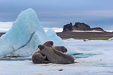
[90] The Russian Arctic stock of this species, ranging from Cape Farewell in Greenland and Svalbard/Spitsbergen areas to East Siberian Sea is considered to be the most endangered of all bowhead populations in the world.
A contributing factor to the low utilization is the difficulty of obtaining permissions and frequent closing of the Kola Bay to accommodate military exercises.
The most frequent service is a three-week North Pole tour with Russian nuclear-powered icebreaker 50 Let Pobedy, which stops by the islands en route.