Friuli-Venezia Giulia
A natural opening to the sea for many central European countries, the region is traversed by the major transport routes between the east and west of Southern Europe.
In fact, the city of Aquileia, founded in 181 BC, served as the regional capital and rose to prominence in the Augustan era.
In 1077, the Holy Roman Emperor recognized the territorial powers of the Patriarchate of Aquileia that temporarily extended its rule to areas to the east; however, by the 12th century the County of Gorizia had become independent.
With the 1797 Treaty of Campo Formio, Venetian domination came to an end and Friuli was ceded to the Habsburg Monarchy (formally part of the Austrian Empire from 1804); however, Austria was forced to cede it to the Napoleonic Kingdom of Italy in the 1805 Peace of Pressburg, along with the parts of the County of Gorizia and Gradisca west of the Isonzo (the boundary was formalized in the 1807 Treaty of Fontainebleau).
In 1849 Illyria was abolished and Gorizia and Trieste both became part of the Austrian Littoral crown land, along with Istria and several islands in the Kvarner Gulf.
The Third Italian War of Independence led to the annexation of Lombardy-Venetia, including Friuli, to the Kingdom of Italy, while the Littoral remained in Austrian hands.
It borders Austria to the north and Slovenia to the east, the three countries meeting at the tripoint on the mountain of Dreiländereck, known as Monte Forno in Italian.
The total area is subdivided into 42.5% mountainous-alpine terrain in the north, 19.3% is hilly, mostly to the southeast, while the remaining 38.2% comprises the central and coastal plains.
The area is also known for its tourist destinations, especially during the winter season (Monte Zoncolan, Tarvisio, Sella Nevea, Forni di Sopra and Piancavallo).
The Carso has geological features and phenomena such as hollows, cave networks, and underground rivers, which extend inland in the provinces of Trieste and Gorizia, with an altitude ranging between 300m and 600m.
These generate a very special feature of the local climate: the north-easterly wind Bora, which descends onto the Gulf of Trieste with gusts occasionally exceeding speeds of 150 km/h.
Its core is based on small and middle-size enterprises (the so-called "North-East model"), on specialized farming and on high-quality tourism with a significant inclination towards exports.
Its products are exported not only within the country and Europe (fruit and vegetables, cheese) but have become known worldwide for their acclaimed quality (cured ham and wines, especially white ones).
These districts are centred around the towns of Manzano, San Daniele del Friuli (cured ham), Maniago (knives), and Brugnera (furniture).
[16] In the services sector, the city of Trieste plays a leading role (with knock-on effects on the other provincial capitals); it is here that activities such as the regional government, large banking, and insurance companies are concentrated.
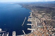
[17] With its commercial Free Port, Trieste also plays an essential role in the trade sector: special custom regulations ensure exclusive financial conditions to operators.
The motorway network consists of more than 200 km that runs from North to South and from West to East, connecting the region to Austria and Slovenia.
It is the Italian port with the greatest capacity for covered storage, with a surface area of more than 2 million square meters and 70 km of rail tracks.
Intermodality is guaranteed by the Cervignano terminal, in operation since 1988, to serve the increasing commercial traffic between Italy and Eastern European countries.
The region is now placing much of its hopes for future economic development in the construction of a high-speed European Transport Corridor n° V connecting Lyon, Turin, Venice, Trieste, Ljubljana, Budapest, and Kyiv, so as to improve the traffic of goods and services with new EU partners.
[16] Friuli-Venezia Giulia has many small and picturesque villages, 13 of them have been selected by I Borghi più belli d'Italia (English: The most beautiful Villages of Italy),[18] a non-profit private association of small Italian towns of strong historical and artistic interest,[19] that was founded on the initiative of the Tourism Council of the National Association of Italian Municipalities.
[23] In 2019, they were all reactivated as "regional decentralization entities" (Italian: Enti di decentramento regionale, or EDR) beginning on 1 July 2020.
[24] In anticipation of this 2017 and 2018 abolition of the provinces in Friuli-Venezia Giulia, the Regional Council created a system of 18 Intermunicipal Territorial Unions (Italian: Unioni territoriali intercomunali, or UTI).
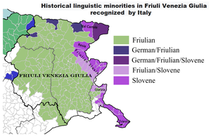
Friulian and Venetian are more common in the countryside, while standard Italian is the predominant language in the larger towns (Udine, Pordenone, Gorizia).
The official, modern "Friuli-Venezia Giulia" flag logo was issued in 1967–1968[28] (and adopted in 2001) to represent the region which in 1963[29] took the administrative setup of today.