Gabriel de Vallseca
[2] By 1433, Vallseca had left Barcelona and was living in Palma, Majorca, where he soon made a name for himself as a master cartographer, instrument-maker and merchant.
He married Floreta Miró and had two sons, Francesc and Joan, both of whom later had run-ins with the Spanish Inquisition for "judaizing", which suggests their father Gabriel may also have been a crypto-Jew.
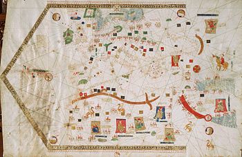
Gabriel de Vallseca's charts retain some signature Majorcan decorative motifs, such as the wind rose, miniature humans, animals and plants, the Atlas Mountains shaped as a palm, the Alps as a chicken's foot, Bohemia as a horseshoe, the Danube as a chain, the Tagus as a shepherd's crook, the Red Sea colored red, and scattered notes and labels in the Catalan language.
The 1439 Vallseca map was acquired in Florence by the Cardinal Antonio Despuig y Dameto sometime before 1785, and subsequently came into the possession of his heirs, the Majorcan Counts of Montenegro.
The map suffered an accident in the winter of 1838/39, when the Count of Montenegro was in the process of showing it to his visitors, Frédéric Chopin and George Sand.
In 1943, historian Damião Peres proposed Diogo de Silves and the date as 1427, which is now commonly cited in Portuguese sources.
[11] Other readings decipher "deserta" (rather than de Sperta), "jlla bela" (instead of Guatrilla), illa aucells or jlha aurolls (instead of Osels/Uccello), faucols (instead of Frydols) and raio marnos or vegis marins (instead of Corp-Marinos).
There is one reproduction of the map, made in 1892 for an exhibition on the 4th centenary of Columbus in Spain, that is currently in the possession of the Naval Museum of Madrid.