Catalan Atlas
[4] It was produced by the Majorcan cartographic school, possibly by Cresques Abraham, a Jewish book illuminator who was described by a contemporary as a master of mappae mundi as well as of compasses.
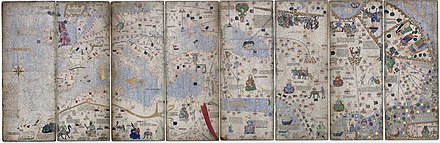
The Catalan Atlas originally consisted of six vellum leaves (each circa 64.5 by 50 cm [25.4 by 19.7 in]) folded vertically, painted in various colours including gold and silver.
[6] They were later mounted on the front and back of five wooden panels, with the ends enclosed in a leather binding by Simon Vostre c. 1515, restored most recently in 1991.
[8] The oriental portion of the Catalan Atlas illustrates numerous religious references as well as a synthesis of medieval mappae mundi and the travel literature of the time, especially Marco Polo's Book of Marvels and Mandeville's Travels and Voyage of Sir John Mandeville.
[9] The explanatory texts report customs described by Polo and catalogue local economic resources, real or supposed.
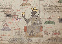
[4] The caption next to the illustration of Mansa Musa reads: "This black Lord is called Musse Melly and is the sovereign of the land of the negroes of Gineva [Guinea].
[22] The Mongol Il-Khanate ruler and his dominions are depicted in the area of Persia under the title "Rey del tauris", after his capital city of Tabriz.
[23][15] The caption is only related to the city of Babylon: Here there was the Great Babylonia, where Nabuconodosor resided, and that is called Baldaca today.
The ruler named Jani Beg has been identified in this representation, being mentioned as "Jambech senyor de Sarra", and the flag of the Golden Horde also appears ().
[23] The caption to the right reads: Here resides the emperor of this northern region whose empire starts in the province of Bulgaria and ends at the city of Organcio.
[28] The text to the left reads: Let it be known that those that wish to cross this desert stop and rest during a week in a city named Lop.
[20]The Anatolian Beyliks, a group of Turkic principalities in Anatolia are also depicted, in the region labelled Turqhia (Turkey).
The caption next to the seated ruler in Anatolia reads: Asia Minor also called Turkey, where there are many cities and castles.
[30] The Christian kingdom of Cilician Armenia appears heavily fortified within green walls, with its ports and flags (, ) clearly visible.
[35] The cities of Cathay, at that time the Empire of the Great Khan (Yuan China), are shown raising a flag with three red crescent moons ().
He will be raised in Goraym of Galilea, and at the age of thirty he will start to preach in Jerusalem; contrary to the truth, he will proclaim that he is Christ, the living son of God.


 )
[
24
]
)
[
24
]


 , dated 1273–1275


 ) appears on all the territory.
