Galatian War
The Romans had then turned their attention towards the Gallic tribes of Galatia who were known for making frequent raids into other cities in Asia Minor and possessing much loot.
Joined by troops from Pergamum, the Romans marched inland, avoiding cities held by the Seleucids and attacking those which had not formally allied with the latter.
The Romans defeated the Galatians in the battle on Mount Olympus, thought to be either Çile Dağı, a hill located between Gordion and Ancyra; or Alis Daği in northern Galatia, on the border with Bithynia.
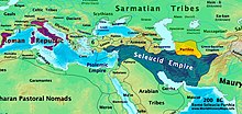
These defeats forced the Galatians to sue for peace and the Romans returned to the coast of Asia Minor, where Vulso concluded the Treaty of Apamea with the Seleucids.
As a result of the campaign, Greco-Asian religious rituals and luxury began to be introduced to Rome, which ancient historians blamed for the moral decline of the Roman Republic.
[2] Gnaeus Manlius Vulso, elected a Roman consul for 189 BC and deployed to Asia, arrived at Ephesus during the spring season.
Three modern historians have thus argued that the Senate was aware of the likelihood of a war with the Galatians,[9] and that it had allowed the continued deployment of the army either to counterbalance the Seleucids or fill the power vacuum created by their defeat.
[9] For the size of this army, the historian John D. Grainger arrives at a possible range of 30 to 35 thousand total soldiers, including those fielded by the allies.
They advanced inland, passing Magnesia on the Maeander and the city of Alabanda where they were met by 1,000 infantry and 300 cavalry led by Attalus's brother, Athenaeus.
[7] They then marched to Antiochia where they were met by Antiochus' son, Seleucus, who offered food supplies as part of the treaty that was being concluded.
The army plundered Laco/Lagon (Lagbe), then crossed the River Cobulatus/Colobatus (the upper Istanos Çay),[19][20] where he was met by ambassadors from Sinda, a town in Pisidia.
[d][29] Grainger argues that 275 talents of silver and 60,000 medimnoi of grain was the minimum total loot during the marches,[30] the food being sufficient for 41 days for about 35,000 soldiers.
While they were there, the Galatian cavalry attacked the army's advance guard, drove it back towards the Roman camp and caused significant casualties.
When the Roman legionaries finally stormed the Galatian camp, the defenders fled down the mountains; many fell down cliffs or succumbed to attacks by the Roman-allied cavalry at the foothills.
[54][55] After the Roman victory at Mount Olympus, the Tectosagi under the command of their chief Komboiomaros asked to meet Vulso for a conference halfway between their camp and Ancyra.
[60] The location of Mount Magaba, where this battle was fought, is thought to be Elmadağ, a hill around 10 miles (16 km) to the east[61] of modern day Ankara.
[62] When the Galatian envoys came, Vulso told them that King Eumenes II of Pergamum would give them the terms of the peace when he returned from Rome.
[63] The terms given to the Galatians at Lampsacus[64] were to cease their raids and to stay confined within their own lands, however, they were not put under Roman or allied control and were left free.
[85]The historian Philip Kay argues that the loot brought by Manlius contributed to and drove increased spending on infrastructure, particularly by the censors of 184, 179 and 174 BC.
[87] Some projects named by Kay are the new port of and commercial infrastructure in Rome in the late 190s BC; the remodeling of the Roman sewerage system (the Cloaca Maxima) with a total expenditure of 6 million denarii; the construction and renovation of roads in Italy; and the building of large structures such as the Basilica Porcia, the Pons Aemilius, the Basilica Aemilia, and a Macellum at an unnamed location in 179 BC, among others.
[93] Grainger further argues that Vulso had the powers to negotiate with the Galatians and all other kingdoms east of the Taurus Mountains, which he wouldn't have had without approval from the Senate.
[94] Livy had written about a combined total of 4,000 soldiers deployed by Morzius (the prince of Paphlagonia) and king Ariarathes IV of Cappadocia being present near Ancyra.
[95] The historian Felix Stähelin notes that the Rhodians suspected that the war with Galatians had been conducted partly for the benefit of the Attalids.
He cites Livy who had observed that the Galatians had relied entirely on passive defenses against a possible siege, but had not armed themselves with long range ballistic weapons.
[58] Grainger argues that the strategy of the Galatians had been to keep the Roman army in the vicinity of their mountainous strongholds till winter arrived, when they would be cut off.
[97] The historian Karl Strobel [de], however, contends that the Galatians had resumed their raids in Asia Minor at the beginning of the 2nd century BC.
[99] The historian Heinz Heinen argues that Vulso's campaign completed the long historical process of confining the Galatians to Galatia; their first settlements in Asia Minor had been in the coastal regions.
[102] Kremer notes how Manlius had told his soldiers before the battle about the Galatians' low endurance, and how they could be defeated if their initial energetic attacks were repulsed.
Bean posits that the route Vulso had most likely used was via modern day Ürkütlü [tr] to Hacıbekâr, then going northward, crossing the Samasbeli Pass and reaching the heights around Aziziye and Bozlar.
Bean posits that Vulso would then have marched from modern Aziziye to the Lysis river valley between Kozluca and Elmacık, and then finally to Cormasa.