Galindez Island
An observation spot and a disused hut are located on the southeastern extremity of Winter Island.
It was reported (1957) that water is obtainable during the summer months from a large pond located on the northern extremity of Galindez Island.
Anchorage can be taken in a position about 200 yards northward of the point, where ringbolts ashore permit the securing of the stern.
Meek Channel has a least depth of 26 feet in the fairway and appears to be clear of dangers except for Corner Rock, which lies in the eastern entrance shout 100 yards northeastward of the northeastern extremity of Galindez Island, and a reef, with 7 feet over It, which extends about 50 yards northward from the north-western part of Galindez Island.
A vessel anehoring off the northern extremity of Galindez Island can secure her stern to ringbolts ashore.
[4] Galindez Island was discovered by the French Antarctic Expedition, 1903–05 (FrAE), under Jean-Baptiste Charcot, who named it for Commander Ismael Galindez of the Argentine Navy, who was dispatched in the Uruguay to search for Charcot, when the expedition was feared lost early in 1905.
The island was recharted by the British Graham Land Expedition (BGLE) under John Rymill, 1934–37.
[1] The BGLE hut on Winter Island disappeared in mysterious circumstances (possibly due to a tsunami) in 1946.
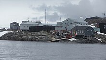
After 30-odd years of continuous occupation as a geophysical, magnetic, ionospheric, atmospheric and meteorological observatory, Station F was rebuilt by BAS in 1980, before being abandoned and handed over to Ukraine on 6 February 1996 and renamed Vernadsky Research Base.
First surveyed in 1935-36 by the BGLE under Rymill and named by members of the expedition for Princess Marina, later Duchess of Kent, who was married in November 1934, while the ship Penola was enroute to the Argentine Islands.
A. Milne's Winnie-the-Pooh which leaves tracks in the snow, in reality made by the tracker who is unaware that he is walking in circles.
The hill was extensively used for ice observations and, as it can be approached from any direction, encircling tracks were often seen from the summit.
Named by the UK-APC in 1959 for Able Seaman Vincent T. Bloor, Royal Navy, a member of the British Naval Hydrographic Survey Unit in the area in 1957-58.
Meek, marine architect and surveyor, who was of assistance in preparing the expedition ship Penola for the voyage.
So named in 1954 by the UK-APC because a prominent cornice overhangs the ice cliff on the Galindez Island side of the channel.