Gangnido
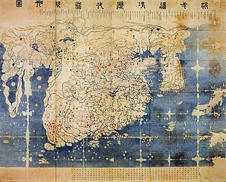
The Honil Gangni Yeokdae Gukdo Ji Do ("Map of Integrated Lands and Regions of Historical Countries and Capitals (of China)"[1]), often abbreviated as Kangnido, is a world map completed by the Korean scholars Kwon Kun and Yi Hoe in 1402, during the Joseon dynasty.
It is also one of the oldest surviving world maps from East Asia, along with the Chinese Da Ming Hunyi Tu (ca.
One claims that it was purchased by Ōtani Kōzui and others assume that it was looted during the Japanese invasions of Korea (1592-1598) (1592–1598) and given to the West Honganji temple by Toyotomi Hideyoshi.
[6] It contains some place names of Korea that are newer than 1402, suggesting that the Ryūkoku copy was partially modified from the 1402 original around the 1470s and 1480s.
Based on a legend of the temple, it has been assumed naively that the Honmyōji copy was given to Katō Kiyomasa, the ruler of Kumamoto, by Toyotomi Hideyoshi in preparation for the Korean campaigns.
However, the Annals of Joseon Dynasty reports that in 1593 the son of a Korean official who had surrendered to Katō copied and offered map(s) of China and Korea to him.
An important clue is provided by Wu Sidao's (烏斯道) anthology titled Chuncaozhai Ji (春草齋集), where Wu stated that he had merged a map named Guanglun Tu (廣輪圖) and Li Rulin's (李汝霖) Shengjiao Beihua Tu (聲教被化圖).
[16] In the East, geographic information about the West was not updated in the post-Mongol period until Europeans such as Matteo Ricci brought Western knowledge.
Names based on Chinese geography were placed to the north and east of Besh Baliq even if they are actually located to the west.
For example, the Talas River, a historic site for the Tang dynasty, was placed to the northeast of Besh Baliq although its actual direction is northwest.
Similarly, India and Tibet are based on traditional Chinese knowledge, mainly gained by Buddhist pilgrimage up to the Tang dynasty.
To the north of the African continent, beyond the unexplored "black" central mass, a pagoda is represented for the lighthouse of Alexandria, and the Arab word "Misr" for Cairo (al-Qāhira) and Mogadishu (Maqdashaw) are shown among others.
The Hunyi Jiangli Tu by Zen monk Qingjun (1328–1392) was one of historical maps that were popular among Chinese literati.
But contrary to Song period maps which reflected limited Chinese knowledge on geography, it incorporated information on Mongolia and Southeast Asia.
[24] Although Gwon Geun did not clarify which map was utilized for Korea, it is usually identified as Yi Hoe's Paldodo (八道圖).
But the original condition of the Korean portion is unclear because even the oldest Ryūkoku copy reflects the administrative situation as late as around 1470.
[25] The modified version of Qingjun's map provides a relatively proper shape of Korea though place names presented there are those of the preceding Goryeo dynasty.
According to the Records of the Grand Historian, Xu Fu claimed that there were three divine mountains in the sea and went to one of the mountain-islands, which were later believed to be Japan.
[29] The original source map, which Gwon Geun did not cite, either is usually identified as the one obtained in Japan supposedly in 1401 by Bak Donji (朴敦之), based on an article of the Sejong Sillok (the 10th month of 1438).
[30] This map originated from a historical setting of the Mongol Empire, which connected the western Islamic world with the Chinese sphere.
Qingjun, who was from neighboring Taizhou, created the historical map of Hunyi Jiangli Tu when he stayed in Qingyuan.
In addition, Qingyuan-lu was one of the most important seaports from which the sea routes were extended to Fuzhou and Guangzhou, and Southeast Asia, Japan and Korea.
Korea, at the time under the Goryeo dynasty (918–1392), was closely integrated into the Mongol Empire as a quda (son-in-law) state.
Earlier studies presumed that the two Chinese source maps had been obtained during Kim Sa-hyeong's diplomatic trip to Ming China in 1399 although there is no literary evidence for his acquisition.
[34] Japanese scholar Miya Noriko presumes that the year 1402 was a landmark for the reigning King Taejong of the newly founded Joseon dynasty.