Gansu
The Northern Silk Road ran through the Hexi Corridor, which passes through Gansu, resulting in it being an important strategic outpost and communications link for the Chinese empire.
[citation needed] Until 1987, Gansu was rendered in the postal romanization and Wade-Giles as Kansu, which was gradually replaced by pinyin starting in 1958.
[10] In imperial times, Gansu was an important strategic outpost and communications link for the Chinese empire, as the Hexi Corridor runs along the "neck" of the province.
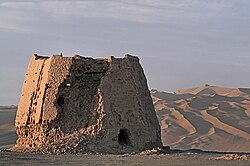
The Han dynasty extended the Great Wall across this corridor, building the strategic Yumenguan (Jade Gate Pass, near Dunhuang) and Yangguan fort towns along it.
To the west of Yumenguan and the Qilian Mountains, at the northwestern end of the province, the Yuezhi, Wusun, and other nomadic tribes dwelt (Shiji 123), occasionally figuring in regional imperial Chinese geopolitics.
By the Qingshui treaty, concluded in 823 between the Tibetan Empire and the Tang dynasty, China lost much of western Gansu province for a significant period.
[13] An early form of paper inscribed with Chinese characters and dating to about 8 BC was discovered at the site of a Western Han garrison near the Yumen pass in August 2006.
As a result of frequent earthquakes, droughts and famines, the economic progress of Gansu was significantly slower than that of other provinces of China until recently.
][23] The Kuomintang Islamic insurgency in China (1950–1958) was a prolongation of the Chinese Civil War in several provinces including Gansu.
Gansu has an area of 454,000 square kilometres (175,000 sq mi), and the vast majority of its land is more than 1,000 metres (3,300 ft) above sea level.
A natural land passage known as Hexi Corridor, stretching some 1,000 kilometres (620 mi) from Lanzhou to the Jade Gate, is situated within the province.
However, due to extreme altitude, some areas of Gansu exhibit a subarctic climate (Dwc) – with winter temperatures sometimes dropping to −40 °C (−40 °F).
[32] The governor is responsible for all issues related to economics, personnel, political initiatives, the environment and the foreign affairs of the province.
[33] Due to poor natural conditions such as aridness, Gansu is one of the Chinese provinces with smallest per capita area of arable land.
However, pollution by heavy metals, such as cadmium in irrigation water, has resulted in the poisoning of many acres of agricultural land.
As stipulated in the country's 12th Five Year Plan, the local government of Gansu hopes to grow the province's GDP by 10% annually by focusing investments on five pillar industries: renewable energy, coal, chemicals, nonferrous metals, pharmaceuticals and services.
[citation needed] A large part of Gansu's economy is based on mining and the extraction of minerals,[39] especially rare earth elements.
The province has significant deposits of antimony, chromium, coal, cobalt, copper, fluorite, gypsum, iridium, iron, lead, limestone, mercury, mirabilite, nickel, crude oil, platinum, troilite, tungsten, and zinc among others.
Gansu is 89.4% Han[54] and also has Hui, Tibetan, Dongxiang, Tu, Uyghurs, Yugur, Bonan, Mongolian, Salar and Kazakh minorities.
Modern Gansu is dominated by Lanzhou city and Linxia Hui prefectures, their growth hides the stark fact that much of the rest of the province is rapidly losing population.
[55] The cuisine of Gansu is based on the staple crops grown there: wheat, barley, millet, beans, and sweet potatoes.
Muslim restaurants are common, and feature typical Chinese dishes, but without any pork products, and instead an emphasis on lamb and mutton.
In 366 AD under the Former Liang dynasty, a monk named Le Zun (Lo-tsun) came near Echoing Sand Mountain, when he had a vision.
Located about 5 km (3.1 mi) southwest of the city, the Crescent Lake or Yueyaquan is an oasis and popular spot for tourists seeking respite from the heat of the desert.
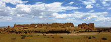
Begun in 420 AD during the Western Qin dynasty, the site contains dozens of caves and caverns filled with outstanding examples of carvings, sculpture, and frescoes.
It has 6 dratsang (colleges), and houses over sixty thousand religious texts and other works of literature as well as other cultural artifacts.
Ninety-four minerals have been found and ascertained, including nickel, cobalt, platinum, selenium, casting clay, finishing serpentine, whose reserves are the largest in China.
The Gansu Wind Farm project – already producing 7.965GW in 2015[60] – is expected to achieve 20GW by 2020, at which time it will likely become the world's biggest collective windfarm.
In November 2017 an agreement between the Chinese Academy of Sciences and Gansu government was announced, to site and begin operations of a molten salt reactor pilot project in the province by 2020.
[63] The Asian Development Bank is working with the State Forestry Administration of China on the Silk Road Ecosystem Restoration Project, designed to prevent degradation and desertification in Gansu.