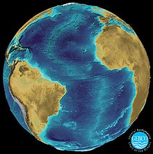
General Bathymetric Chart of the Oceans
The GEBCO chart series was initiated in 1903 by an international group of geographers and oceanographers, under the leadership of Prince Albert I of Monaco.
At that time there was an explosion of interest in the study of the natural world and this group recognized the importance of a set of maps describing the shape of the ocean floor.
The Nippon Foundation-GEBCO Seabed 2030 Project, which aims to motivate a number of collaborators to create a full map of the ocean floor, was launched in 2016.
About 14,500,000 square kilometres (5,600,000 sq mi) of new bathymetric data was included in the GEBCO grid in 2019, and an additional area equivalent to the size of Europe between 2020 and 2022.
The British Antarctic Survey is assisting the effort by varying the routes of its boats in order to map different parts of the sea floor.