Geocaching
[5] Geocaching shares many aspects with benchmarking, trigpointing, orienteering, treasure hunting, letterboxing, trail blazing, and another type of location-based game called Munzee.
[13] According to Dave Ulmer's message, this cache was a black plastic bucket that was partially buried and contained various items, such as software, videos, books, money, a can of beans, and a slingshot.
[14] Geocaching company Groundspeak allows extraterrestrial caches, e.g. the Moon or Mars, although presently, the website provides only earthbound coordinates.
[17] The original cache contained a Travel Bug (the first geocaching trackable item in space), which stayed on the station until it was brought back to earth in 2013.
[20] Geocachers were given the opportunity to virtually discover the trackable after the WATSON camera sent back its first photographs of the calibration target that contained the tracking code number.
This was changed shortly after the original hide when it was suggested in the gpsstash eGroup that "stash" could have negative connotations and the term geocaching was adopted.
[22] An independent accounting of the early history documents several controversial actions taken by Jeremy Irish and Grounded, Inc., a predecessor to Groundspeak, to increase "commercialization and monopolistic control over the hobby".
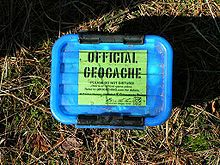
[25] Typical cache "treasures", also known in the geocaching world as SWAG (a backronym of "stuff we all get"),[26][27] are not high in monetary value but may hold personal value to the finder.
[25] Aside from the logbook, common cache contents are unusual coins or currency, small toys, ornamental buttons, CDs, or books.
[26] Disposable cameras are popular as they allow for anyone who found the cache to take a picture which can be developed and uploaded to a geocaching web site listed below.
Geocaches may also be complex, involving lengthy searches, significant travel, or use of specialist equipment such as SCUBA diving, kayaking, or abseiling.
Ammo cans are considered the gold standard of containers because they are very sturdy, waterproof, animal- and fire-resistant, and relatively cheap, and have plenty of room for trade items.
Since 2017, Groundspeak has required new challenges to have a geochecker in which users can put their name into an algorithm to see if they qualify without the need of physically checking all of one's previous finds.
Authors can develop self-enclosed story files (called "cartridges") that are read by the Wherigo player software, installed on either a GPS unit or smartphone.
The player and story take advantage of the location information provided by the GPS to trigger in-game events, such as using a virtual object or interacting with characters.
Earthcaches covers geologic topics such as: rock formation, mineralogy, earthquakes, fluvial processes, erosion, volcanology, and planetary science (among others).
[55] Some websites allow geocachers to search (build queries) for multiple caches within a geographic area based on criteria such as ZIP code or coordinates, downloading the results as an email attachment on a schedule.
Newer GPS devices released by Garmin, DeLorme, and Magellan have the ability to read GPX files directly, thus eliminating the need for a PDA.
[88][86] Events and caches are often organized revolving around this practice, with many areas seeing significant cleanup that would otherwise not take place, or would instead require federal, state, or local funds to accomplish.
[81][92] As well as concerns about littering and bomb threats, some geocachers have hidden their caches in inappropriate locations, such as electrical boxes, which may encourage risky behavior, especially by children.
[93] The South Carolina House of Representatives passed Bill 3777[94] in 2005, stating, "It is unlawful for a person to engage in the activity of Geocaching or letterboxing in a cemetery or in a historic or archaeological site or property publicly identified by a historical marker without the express written consent of the owner or entity which oversees that cemetery site or property."
[102] In 2008, two lost hikers on Mount Hood in Oregon, U.S. stumbled across a geocache and phoned this information out to rescuers, allowing crews to locate and rescue them.
Rochester Fire Department spokesman Lt. Ted Kuppinger said, "It's difficult, because you're invested in it, you want to find something like that, so people will probably try to push themselves more than they should, but you need to be prudent about what you're capable of doing.
"[104] In 2015, members of the public called the British coastguard to check on a group of geocachers who were spotted walking into the Severn Estuary off the coast of Clevedon, England, in search of clues to locate a multi-cache.
.Geocaching websites vary in many ways, such as subscription options, activity levels, and volunteers available to check and ensure caches registered remain open for others.
[110] On September 2, 2000, Jeremy Irish emailed the gpsstash mailing list that he had registered the domain name geocaching.com and had set up his own Web site.
With a worldwide membership and a freemium business model, the website claims millions of caches and members in over 190 countries and all seven continents including Antarctica.
The Opencaching Network lists the most types of caches, including traditional, virtual, moving, multi, quiz, webcam, BIT, guest book, USB, event, and MP3.
The site's geodashing game generated a large number of randomly positioned "dashpoints", requiring players to reach as many as possible, competing as individuals or teams.
Geocaching.com and OX are both backed by large enterprises, and while that means they have more funding and people, we're a much smaller team – so our advantage is the ability to be dynamic and listen to the users.


Bottom: a large bucket geocache in the Czech Republic .