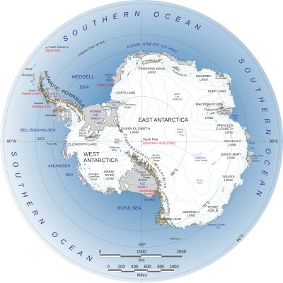
Geography of Antarctica
In September 2018, researchers at the National Geospatial-Intelligence Agency released a high resolution terrain map (detail down to the size of a car, and less in some areas) of Antarctica, named the "Reference Elevation Model of Antarctica" (REMA).
[4] Researchers find it difficult to properly identify volcanic activity due to the comprehensive ice covering.
While there are some indications that there is volcanic activity under the East Antarctic Ice Sheet, there is not a significant amount of present information on the subject.
The Marie Byrd Land makes up a large portion of West Antarctica, consisting of the Area below the Antarctic Peninsula.
The Marie Byrd land is a large formation of volcanic rock, characterized by 18 exposed and subglacial volcanoes.
Scientists and researchers debate whether or not the 138 identified possible volcanoes are active or dormant.
It is very hard to definitively say, given that many of these volcanic structures are buried underneath several kilometers of ice.
Scientists remain uncertain about the presence of water underneath the West Antarctic Ice Sheet, with some claiming to have found evidence indicating the existence.
In West Antarctica's Marie Byrd Land, volcanoes are typically composed of alkaline and basaltic lava.
Due to the geographic similarity of the Marie Byrd Land, it is believed that the volcanoes in the West Antarctic Rift System are also composed of basalt.
[4] Since they are formed from repeated piling of liquid magma sourced from the center, they spread widely and grow upwards relatively slowly.
Polygenetic subglacial volcanoes have a wider variety of shapes and sizes due to being made up of many different eruptions.
It is likely that an eruption at lower latitudes would cause global health and aviation hazards due to ash disbursement.
The clockwise air circulation around the low pressure system at the South Pole forces air upwards, hypothetically sending ash upwards towards the Stratospheric jet streams, and thus quickly dispersing it throughout the globe.
[16] Recently, in 2017, a study found evidence of subglacial volcanic activity within the West Antarctic Ice Sheet.
[17] This could possibly plunge the West Antarctic Ice Sheet into a positive feedback loop of rising temperatures and increased melting.
None of the canyons are visible at the snow-covered surface of the continent since they are buried under hundreds of meters of ice.