Geography of Greece
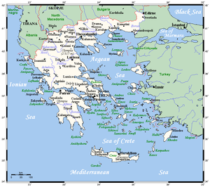
The country consists of a mountainous, peninsular mainland jutting out into the Mediterranean Sea at the southernmost tip of the Balkans, and two smaller peninsulas projecting from it: the Chalkidiki and the Peloponnese, which is joined to the mainland by the Isthmus of Corinth.
According to the CIA World Factbook, Greece has 13,676 kilometres (8,498 mi) of coastline, the largest in the Mediterranean Basin.
The Rhodope Mountains form the border between Greece and Bulgaria; that area is covered with vast and thick forests.
The extreme points of Greece are [10] Greece has notable deposits of petroleum, magnetite, lignite, bauxite, hydropower, marble, limestone[3] Ancient Greeks used limestone as a durable building material in many buildings such as the Parthenon.
Further south, the smaller peninsula of Peloponnese is separated from the rest of the Greek mainland by the Corinthian and Saronic Gulfs, but joined by the Isthmus of Corinth.
The country's tallest mountain is Mount Olympus, which also separates Thessaly from Macedonia.
[14] Paris Match, however, raises this number to 9,841 islands, of which only 169 have a recorded continuous human presence.
[15] The Greek islands account for about 20% of the country's total territory,[16] and vary greatly in size as well as in climate.
Many of the smaller Greek islands form groups or chains, often called archipelagos, with notable examples being the Cyclades and the Sporades in the south and central Aegean Sea respectively.
The six northern islands lie off the western coast of Greece, in the Ionian Sea.
Kythira is part of the modern administrative region of Attica, not the Ionian Islands (Ionioi Nisoi).
The Ionian Islands are distinct from the historical region of Ionia, which is today part of western Turkey.
Crete is characterized by a mountain range crossing from west to east, formed by three different subranges: These encompass fertile plateaus, such as Lasithi, Omalos and Nidha; caves such as Diktaion and Idaion; and gorges such as the Samariá Gorge.
Greece's natural hazards include severe earthquakes, floods, droughts and wildfires.
In the eastern part of the country and especially in the archipelago, a cooling Etesian wind blows in the summer, but in big cities like Athens it can get sweltering hot.