Geography of Guadeloupe
Guadeloupe is an archipelago of more than 12 islands, as well as islets and rocks situated where the northeastern Caribbean Sea meets the western Atlantic Ocean.
[1][3] In contrast Grande-Terre is mostly flat, with rocky coasts to the north, irregular hills at the centre, mangrove at the southwest, and white sand beaches sheltered by coral reefs along the southern shore.
[4] Marie-Galante is the third-largest island, followed by La Désirade, a north-east slanted limestone plateau, the highest point of which is 275 metres (902 ft).
Because of the porous soil and lack of mountains to catch rainfall, agriculture is limited by insufficient water.
[4] La Désirade, east of the main islands, has a basement from the Mesozoic, overlaid with thick limestones from the Pliocene to Quaternary periods.
[9] Grande-Terre and Marie-Galante have basements probably composed of volcanic units of Eocene to Oligocene, but there are no visible outcrops.
[11] On 16 September 1989, Hurricane Hugo caused severe damage to the islands of the archipelago and left a deep mark on the memory of the local inhabitants.
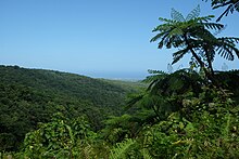
The dry forest occupies a large part of the islands of Grande-Terre, Marie-Galante, Les Saintes, La Désirade and also develops on the leeward coast of Basse-Terre.
The coastal forest is more difficult to develop because of the nature of the soil (sandy, rocky), salinity, sunshine and wind and is the environment where the sea grape, the mancenilla (a very toxic tree whose trunk is marked with a red line), the icaquier or the Coconut tree grow.
The Mangrove forest that borders some of Guadalupe's coasts is structured in three levels, from the closest to the sea to the farthest.
[12] In recent decades, Guadeloupe's natural environments have been affected by hunting and fishing, forest retreat, urbanization and suburbanization.
They also suffer from the development of intensive crops (banana and sugar cane, in particular), which reached their peak in the years 1955–75.
This has led to the following situation: seagrass beds and reefs have degraded by up to 50% around the large islands; mangroves and mantids have almost disappeared in Marie-Galante, Les Saintes and La Désirade; the salinity of the fresh water table has increased due to "the intensity of use of the layer"; and pollution of agricultural origin (pesticides and nitrogenous compounds).
[13] In addition, the ChlEauTerre study, unveiled in March 2018, concludes that 37 different anthropogenic molecules (more than half of which come from residues of now-banned pesticides, such as chlordecone) were found in "79% of the watersheds analyzed in Grande-Terre and 84% in Basse-Terre."
As a result, on 8 December 1993, the marine site of Grand Cul-de-sac was listed as a wetland of international importance.
On 21 November 2004, the islands of the department, in particular Les Saintes archipelago, were shaken by a violent earthquake that reached a magnitude of 6.3 on the Richter scale and caused the death of one person, as well as extensive material damage.