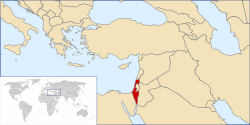
Geography of Israel
Southern Israel is dominated by the Negev desert, covering some 16,000 square kilometres (6,178 sq mi), more than half of the country's total land area.
The north of the Negev contains the Judean Desert, which, at its border with Jordan, contains the Dead Sea which, at −417 m (−1,368 ft) is the lowest point on Earth.
[6] Modern Israel is bounded to the north by Lebanon, the northeast by Syria, the east by Jordan and the West Bank, and to the southwest by Egypt.
Israel is divided into four physiographic regions: the Mediterranean coastal plain, the Central Hills, the Jordan Rift Valley and the Negev Desert.
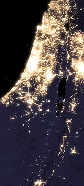
[1] The Israeli Coastal Plain stretches from the Lebanese border in the north to Gaza in the south, interrupted only by Cape Carmel at Haifa Bay.
[dubious – discuss] Today the Kishon, Alexander and Yarkon again flow year round, and also have parks along their banks.
The Sharon Plain is the next section, running from Nahal Taninim (south of Zikhron Ya'akov) to Tel Aviv's Yarkon River.
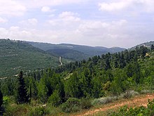
[19] South of the Galilee, in the West Bank, are the Samarian Hills with numerous small, fertile valleys rarely reaching the height of 800 meters (2,625 ft).
Lake Tiberias is 165 square kilometers (64 sq mi) in size and, depending on the season and rainfall, is at about 213 meters (699 ft) below sea level.
[19] South of the Dead Sea, the Rift Valley continues in the Arabah (Hebrew "Arava", Arabic "Wadi 'Arabah"), which has no permanent water flow, for 170 kilometers (106 mi) to the Gulf of Eilat.
[19] The Negev Desert comprises approximately 12,000 square kilometers (4,633 sq mi), more than half of Israel's total land area.
[19] Topographically, it parallels the other regions of the country, with lowlands in the west, hills in the central portion, and the Arava valley as its eastern border.
[23] This can result in rare flash floods during heavy rains as water runs across the surface of the impervious desert soil.
[24] The high plateau area of Ramat HaNegev stands between 370 and 520 meters (1,214 and 1,706 ft) above sea level with extreme temperatures in summer and winter.
[23] The Arabah Valley along the Jordanian border stretches 180 kilometers (112 mi) from Eilat in the south to the tip of the Dead Sea in the north and is very arid with barely 50 millimeters (1.97 in) of rain annually.
[25] The numerous limestone and sandstone layers of the Israeli mountains serve as aquifers through which water flows from the west flank to the east.
Caves in the region have been used for thousands of years as shelter, storage rooms, barns and as places of public gatherings.
[26] The Jordan Rift Valley is the result of tectonic movements within the Dead Sea Transform (DSF) fault system.
[29] Given the fragile political situation of the Middle East region and the presence there of major holy sites, a quake reaching magnitude 7 on the Richter scale could have dire consequences for world peace.
[30] Only the Dan is within undisputed Israel; the Hasbani flows from Lebanon and the Banias from territory captured from Syria in the Six-Day War.
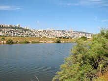
[30] The Sea of Galilee (also called the Kinneret) is Israel's largest and most important freshwater lake, located in the northeast of the country.
[35] The climate conditions are highly variable within the state and modified locally by altitude, latitude, and the proximity to the Mediterranean.
[35] In winter, precipitation often takes the form of snow at the higher elevations of the central highlands, including Jerusalem.
[35] Thunderstorms and hail are common throughout the rainy season and waterspouts occasionally hit the Mediterranean coast, capable of causing only minor damage.
However, supercell thunderstorms and a true F2 tornado hit the Western Galilee in April 2006, causing significant damage and 75 injuries.
[1] In 2009, significant reserves of natural gas were discovered at the Tamar 1 offshore drilling site, 90 kilometers west of Haifa.
[37] Israel has a large number of environmental concerns ranging from natural hazards to man-made issues both resulting from ancient times to modern development.
Natural hazards facing the country include sandstorms which sometimes occur during spring in the desert south, droughts which are usually concentrated in summer months, flash floods which create great danger in the deserts due to their lack of notice, and regular earthquakes, most of which are small, although there is a constant risk due to Israel's location along the Jordan Rift Valley.
[52] Other small, but notable groups in Israel, include Circassians of whom there are approximately 3,000 living mostly in two northern villages, 2,500 Lebanese, and 5,000 Armenians predominantly in Jerusalem.
[53] Israel is ranked 34th in the world in terms of population density with, as noted, a climate of long, hot, rainless summers and relatively short, cool, rainy winters.