Geography of North Macedonia
Conversely, the Šar Mountains, which are located in the northwestern part, block cold northern winds.
[2] Summers are subtropical and it is not uncommon to see temperatures of above 40 °C (104 °F) during this season, especially in the plains along the valley of the Vardar river.
[3] The rainfall is abundant in the western and eastern parts of the country, but the temperature decreases significantly in the Vardar region.
It describes a curve to the south across the River Lepenec and then turns to north-east to traverse Mount Crna before taking a course slightly to the north of east across the landscape features to the tripoint with Bulgaria.
[13] The boundary starts from the tripoint with Kosovo and follows a watershed before crossing, and for a short distance, following the Black Drin river and continuing along a crest line to Ohrid Lake.
North Macedonia is a landlocked country that is geographically clearly defined by a central valley formed by the Vardar river and framed along its borders by mountain ranges.
The terrain is mostly rugged, located between the Šar Mountains and Osogovo, which frame the valley of the Vardar river.
The Black Sea basin is the smallest with only 37 km2 It covers the northern side of Mount Skopska Crna Gora.
It passes through Gostivar, Skopje and into Veles, crosses the Greek border near Gevgelija, Polykastro and Axioupoli, before emptying into the Aegean Sea in Central Macedonia west of Thessaloniki in northern Greece.
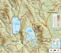
[19] Lake Ohrid (Macedonian: Охридско Езеро, Ohridsko Ezero) straddles the mountainous border between southwestern North Macedonia and eastern Albania.
The lake drains an area of around 2600 km2 and is fed primarily by underground springs on the eastern shore (about 50% of total inflow), with roughly 25% shares from rivers and direct precipitation.
The Great Prespa Lake (Macedonian: Преспанско Езеро, Prespansko Ezero) is divided between Albania, Greece and North Macedonia.
[20] The town of Dojran is situated on the west coast of the lake, while the Greek village of Mouries lies to the east.
Phytogeographically, North Macedonia belongs to the Illyrian province of the Circumboreal Region within the Boreal Kingdom.
North Macedonia is rich in low-grade iron ore, copper, lead, zinc, chromite, manganese, nickel, tungsten, gold, silver, asbestos, and gypsum.
The ornithological reserve of Ezerani, north of Lake Prespa, is 2,000 hectares big and is home to sixty animals protected by the Bern Convention.
Indeed, in order to make North Macedonia, formerly rural and poor, a modern and prosperous country, the Yugoslav communist regime established many factories, often highly polluting.
The emissions of waste pollutants have decreased after 1991, after independence, because many companies have gone bankrupt or have reduced their activity after the transition to a market economy.
Indeed, only the city of Skopje has a processing center for household waste in the rest of the country, so they are left in open dumps.
[24] The environmental degradation nevertheless mobilizes local groups and North Macedonia is a signatory to international treaties like the Kyoto Protocol.
Urbanization, which is developing very fast since the communist era of Yugoslavia, has led to uncontrolled and illegal constructions.
[25] North Macedonia is divided into eight statistical regions: Skopje, Pelagonia, Polog, Vardar, Eastern, Southeastern, Northeastern and Southwestern.
[29] Under Yugoslavia, North Macedonia saw the establishment of many factories and the significant modernisation of the country, especially after the devastating Skopje earthquake of 1963.
[30] Greece, which believed that the republic was monopolising the cultural and historical heritage of Macedonia, imposed a temporary embargo in 1993 and had prevented the country's accession to organisations like the European Union and NATO, until the implementation of the Prespa agreement in 2019.
This highway has also been renovated in North Macedonia with the European Agency for Reconstruction, and the communication channels that connect the Adriatic to the Black Sea, called the Corridor VIII, were also upgraded and maintained through international assistance including the Italian one.
The country in fact has substantial deposits of chromium and other nonferrous metals like copper, zinc, manganese and nickel.
The presence of hot springs of volcanic origin can heat the greenhouses in winter, particularly in the Strumica region, whose products include tomatoes and cucumbers in the month of February.
Different climates provide opportunities for various productions in the geographical area, so the vine and tobacco are operated in the south, the rice in the region of Kočani which is largely irrigated, and the wood industry is concentrated around Štip.
[37] The summer of 2009 was the best tourist season for the city of Dojran with 135,000 overnight visitors, an increase of 12.5% compared to the previous year.
[38] The tourist capital of North Macedonia, Ohrid,[39] has been listed as an UNESCO World Heritage Site since 1979.