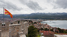
Lake Ohrid
The graben system is still tectonically active and Lake Ohrid sits in a seismogenic landscape, with many visible traces including fresh fault scarps, displaced sediment and soil sequences, stepped hillsides, and a hydrothermal field near Kosel.
Moderate earthquakes are frequent, with the strongest yet measured here on 18 February 1911, with a magnitude 6.6 at a focal depth of 15 km, destroying houses but with no loss of life.
[9] The lake drains an area of around 2,600 km² and is fed primarily by underground springs on the eastern shore (about 50% of total inflow), with roughly 25% shares from rivers and direct precipitation.
The water leaves Lake Ohrid by evaporation (~40%) and through its only outlet, the Black Drin River, which flows in a northerly direction into Albania and thus to the Adriatic Sea.
The relatively dry, Mediterranean climate and the small drainage basin of 2,600 km² (catchment/lake surface ratio of ~7) of Lake Ohrid results in a long hydraulic residence time scale of ~70 yr.[10][11][12] The water at the surface of Lake Ohrid moves predominantly in a counter-clockwise direction along the shore, as a result of wind forcing and the Earth rotation, similar to the Ekman-phenomenon known from oceans.
[19] Changes to the General Urban Plan for Ohrid 2014–2020, however, made provisions for Studenchishte Marsh to be drained and replaced with infrastructure for tourism and water-sports,[16][20] a proposal which, together with other regional developments, was opposed by numerous local and international experts,[21] including the Society of Wetland Scientists.
[25] However, the potential to restore Struga Marsh, which was not included in the boundaries of the Ramsar Site, is likely to be reduced by construction of the European Corridor VIII railway, while Studenchishte's future is yet to be fully resolved.
[27] Whereas the endemic species list cited above is based on morphological and ecological characteristics, some recent applications of molecular genetic techniques underline the difference of the fauna from common European taxa, as well as the old age of the lake.
The Macedonian part of the lake has been designated an Important Bird Area (IBA) by BirdLife International because it supports populations of common coots and pygmy cormorants (Microcarbo pygmaeus).
[34] The Albanian part of the lake has been designated a separate but corresponding IBA for the same reason, with additional bird species being common goldeneyes, red-crested pochards (Netta rufina) and black-necked grebes.
[35] Wetland of International Importance status under the Ramsar Convention is underpinned in part by the biogeographically significant populations of red-crested pochard and pygmy cormorants too, but also goosander (Mergus merganser).
[10][14]Historically, Lake Ohrid was close to a main highway of the Roman Empire, the Via Egnatia, from Durrës on the coast of Albania to Thessalonika and Constantinople (Istanbul), but now is a communications backwater.
Religious monuments such as the Black Madonna south west of Struga and St Naum monastery are counterposed with ravages of war, such as the fortifications of the Macedonian Front across Galicica Mountain.
[39] The lake became part of a mixed Natural and Cultural World Heritage Site in 1980 when the city of Ohrid in Macedonia was also designated with UNESCO status for its architectural, artistic and religious values.
[39] Concern over current and potential deterioration of the World Heritage Site prompted invitation of a joint Reactive Monitoring Mission by the World Heritage Centre, IUCN and ICOMOS in April 2017, which identified a wide range of pressures including from transport infrastructure, traffic, tourism developments, overfishing, sewerage, solid waste disposal, invasive species, both legal and illegal construction, and management of water levels.
[42] In its analysis and conclusions, the World Heritage Centre observed threats to Lake Ohrid from "decreased water levels, uncontrolled discharge, water pollution due to inadequate wastewater treatment systems leading to evident eutrophication at the mouths of intake rivers, heavy pressures from tourism, and extensive uncontrolled urban development and inappropriate exploitation of the coastal zones."
[27] Deep sediment cores augmented by diverse ecology in the present day offer an extensive archive from which to understand the history of its region over the past 1,200,000 years.
[48] Among other contributions, such research has delivered the first empirical evidence for niche-based assembly processes from a natural system and demonstrated the establishment of dynamic equilibrium in an isolated ecosystem during the slowdown of both speciation and extinction rates.
[49] It has also demonstrated the importance of tree cover for buffering soil erosion during times of climate change[50] and provided insight into the composition of regional flora through glacial and inter-glacial periods.
Particular threats are the building of tourist facilities directly at the shore, destroying of reed belts to gain agricultural land and intense pollution close to the mouth of tributaries.
[51] Although there are regulations regarding fishing practice (e.g. minimal mesh size) and only a limited number of licensed fishermen, these rules are always not obeyed as a result of the high market value of the endemic trout.
Although there is time to react, computer simulations indicate that at least a 50% reduction in phosphorus input must be reached to keep the deep water oxygenated for the next 50 years at predicted atmospheric warming.
First steps in that direction have been taken by extending and improving the existing sewage system in North Macedonia in the framework of a GEF (Global Environment Facility) program.
[14][15] On 3 May 2018, the Society of Wetland Scientists released the Declaration on the Protection of the Lake Ohrid Ecosystem, which was passed unanimously by 45 attending members at its 13th annual European meeting.