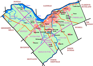
Geography of Ottawa
The Ottawa River forms the entire northern boundary of the city which it shares with the province of Quebec's municipalities of Pontiac and Gatineau.
The boundary then turns south in a straight line, separating the former Township of Cumberland (now in Ottawa) and the City of Clarence-Rockland.
It then turns west in another straight line separating the former Township of Cumberland with the municipalities of The Nation and Russell.
That boundary runs south in a straight line, then turns west separating Osgoode from the municipality of North Dundas.
It separates the municipalities of Montague, Beckwith and Mississippi Mills from the former townships of Marlborough, Goulbourn, Huntley and Fitzroy.