Geography of Turkey
[7] Main articles: The First Geography Congress, held in Ankara between 6–21 June 1941, divided Turkey into seven regions after long discussions and work.
[10] These geographical regions were separated according to their climate, location, flora and fauna, human habitat, agricultural diversities, transportation, topography, etc.
[10] Turkey has a diverse terrain: the plains of Anatolia, and forests of the Black Sea, semi-arid lands, natural lakes and the coastlines of the Aegean and Mediterranean.
The parallel valleys running north to the Black Sea used to be isolated from one another until a few decades ago because the densely forested ridges made transportation and exchange very difficult.
[13] Year-round high[12] precipitation—up to 2200mm[17]—generate dense forests, with oak, beech family trees, hazel (Corylus avellana), hornbeam (Carpinus betulus) and sweet chesnut (Castanea sativa) prevailing.
[18] Isolated from one another because of steep valleys,[3] the Black Sea region includes 850[19] plant taxa of which 116[19] is endemic to the area, and of which 12 are endangered[3] and 19[20] vulnerable.
There are two suspension bridges over the Bosphorus, both its Asian and European banks rise steeply from the water and form a succession of cliffs, coves, and nearly landlocked bays.
Located on the western side of Anatolia, the Aegean region has fertile soil and a typically Mediterranean climate; with mild, wet winters and hot, dry summers.
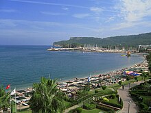
The region also has many important centers of tourism which are known both for their historic monuments and for the beauty of their beaches; such as Assos, Ayvalık, Bergama, Foça, İzmir, Çeşme, Sardis, Ephesus, Kuşadası, Didim, Miletus, Bodrum, Marmaris, Datça and Fethiye.
Toward the east, the extensive Cilician Plain, around Adana, Turkey's fifth most populous city, consist largely of reclaimed flood lands.
Stretching inland from the Aegean coastal plain, the Central Anatolia region occupies the area between the two zones of the folded mountains, extending east to the point where the two ranges converge.
Important irrigated crops include barley, corn, cotton, various fruits, grapes, opium poppies, sugar beets, roses, and tobacco.
Some are no more than a widening of a stream valley; others, such as the Konya Ovası, are large basins of inland drainage or are the result of limestone erosion.
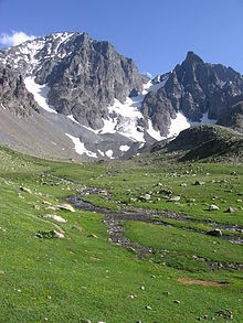
Eastern Anatolia, where the Pontic and Anti-Taurus mountain ranges converge, is rugged country with higher elevations, a more severe climate, and greater precipitation than are found on the Anatolian Plateau.
Traditionally, wheat and barley were the main crops of the region, but the inauguration of major new irrigation projects in the 1980s has led to greater agricultural diversity and development.
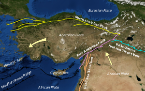
Turkey's varied landscapes are the product of a wide variety of tectonic processes that have shaped Anatolia over millions of years and continue today as evidenced by frequent earthquakes and occasional volcanic eruptions.
Except for a relatively small portion of its territory along the Syrian border that is a continuation of the Arabian Platform, Turkey geologically is part of the great Alpide belt that extends from the Atlantic Ocean to the Himalaya Mountains.
The earliest geological history of Turkey is poorly understood, partly because of the problem of reconstructing how the region has been tectonically assembled by plate motions.
Turkey can be thought of as a collage of different pieces (possibly terranes) of ancient continental and oceanic lithosphere stuck together by younger igneous, volcanic, and sedimentary rocks.
These blocks form a very complex mixture or mélange of rocks that include mainly serpentinite, basalt, dolerite and chert (e.g. Bergougnan, 1975).
The Eurasian margin, now preserved in the Pontides (the Pontic Mountains along the Black Sea coast), is thought to have been geologically similar to the Western Pacific region today (e.g. Rice et al., 2006).
[citation needed] During the Cenozoic folding, faulting, and uplifting, accompanied by volcanic activity and intrusion of igneous rocks was related to major continental collision between the larger Arabian and Eurasian plates (e.g. Robertson & Dixon, 1984).
Present-day earthquakes range from barely perceptible tremors to major movements measuring five or higher on the open-ended Richter scale.
Turkey's most severe earthquake in the twentieth century occurred in Erzincan on the night of December 28–29, 1939; it devastated most of the city and caused an estimated 160,000 deaths.
The most earthquake-prone part of Turkey is an arc-shaped region stretching from the general vicinity of Kocaeli to the area north of Lake Van on the border with Armenia and Georgia.
A central massif composed of uplifted blocks and downfolded troughs, covered by recent deposits and giving the appearance of a plateau with rough terrain, is wedged between two folded mountain ranges that converge in the east.
Mountains close to the coast prevent Mediterranean influences from extending inland, giving the interior of Turkey a continental climate with distinct seasons.
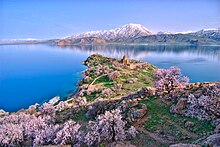
The rocks along the shoreline of Lake Salda were formed over time by microbes;[21][22] these so-called microbialites provide some of the oldest known fossilized records of life.
[21][22] In 2021, NASA reported that its Mars surface-exploring rover Perseverance showed that "the minerals and rock deposits at Lake Salda are the nearest match on Earth to those around the Jezero Crater where the spacecraft landed.