Geography of Victoria
With an area of 227,444 km2 (87,817 sq mi), it is Australia's sixth largest state/territory, comparable in size to the island of Great Britain or the U.S. state of Utah.
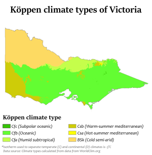
Victoria's main land feature, the Great Dividing Range, produces a cooler, mountain climate in the centre of the state.
The Mallee and upper Wimmera are Victoria's warmest regions with hot winds blowing from nearby semi-deserts.
Victoria's highest maximum temperature of 48.8 °C (119.8 °F) was recorded in Hopetoun on 7 February 2009, during the 2009 southeastern Australia heat wave.
Victoria's highest recorded daily rainfall was 377.8 mm (14.87 in) at Tidal River in Wilsons Promontory National Park on 23 March 2011.
The most important streams flowing southwards to the sea are the Latrobe, Thomson, Macalister, Mitchell, Tambo, Nicholson and Snowy Rivers and their tributaries.
Dendritic patterns of narrow ridges and valleys are typical of the region and characterise much of the deeply dissected landscape on either side of the Great Divide.
Occasional isolated summits such as Mount Buller and Feathertop stand above the remnant plateaus or broad ridges.
These include the Pinnibar plateau in the north-east, Nunniong plains to the south (about 1,200 m), and the Koetong - Shelly, Wabonga and Strathbogie plateaus further north (about 600–1,100 m).
The northerly draining valleys widen and the stream gradients gradually decrease as they near the Riverine Plain to the north and west of the region.
The Eastern Uplands extend to the coast from Cape Conran to Rams Head, where the Nillumbik Terrain is absent, and is fringed with coastal sand dunes in parts.
Tall, thick forests of Alpine Ash occur on the upper mountain slopes, while the world's tallest hardwood tree, Mountain Ash, is found at slightly lower altitudes in the west of the region, with a typical variety of mixed-species eucalypts in conjunction with Ti-Tree shrubs composing the remainder of the forested portion of the Eastern Uplands.